Today's Geocaches
- Owner: bwillsie
- Location: N 41° 06.742' W 075° 54.334'

- Log Type: Found it
- Date: 1 January 2005
- Original Geocaching.com listing
- Owner: AN_OYSTERBOY
- Location: N 41° 11.889' W 075° 53.788'
- Log Type: Found it
- Date: 1 January 2005
- Original Geocaching.com listing
Hi, BW!
Happy New Year!
Two New Year’s Days in a row with sunshine and above average temperatures is too much to hope for, but somehow we’ve managed to experience just that in NEPA. While last January 1 was still brisk, however, this New Year’s Day was truly exceptional—a real beach day!
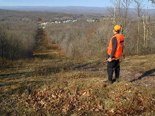
Our adventure began at the SGL parking area along Lake Francis Road near the powerline. Having taken too quick a glance at the map we headed straight up the trail from the parking spot; that led us to the powerline. We followed the powerline trail up and then down a steep hill before realizing that we really should’ve been hiking along the gas pipeline instead of the powerline cut. ![]() Our topo map indicated a connector trail, and we planned to bushwhack to the nearest point, pick up this trail and follow it to the pipeline and the first stage of the cache. But not thirty seconds after making this decision, I spotted another trail which led us north and then turned sharply west, eventually bringing us to the woods road we’d seen on the map. Much better than bushwhacking, and beautiful wooded singletrack to boot! (We’re coming back with mountain bikes.) From the intersection of the woods road and pipeline it was a quarter-mile hike to a colorful view and the first stage of the cache, which we found easily.
Our topo map indicated a connector trail, and we planned to bushwhack to the nearest point, pick up this trail and follow it to the pipeline and the first stage of the cache. But not thirty seconds after making this decision, I spotted another trail which led us north and then turned sharply west, eventually bringing us to the woods road we’d seen on the map. Much better than bushwhacking, and beautiful wooded singletrack to boot! (We’re coming back with mountain bikes.) From the intersection of the woods road and pipeline it was a quarter-mile hike to a colorful view and the first stage of the cache, which we found easily.
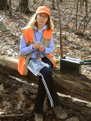
Reaching the second stage required a short bushwhack through swampy woods. We were a little disappointed to find nothing at the coordinates to indicate we were in the right spot, but I understand that this was probably intended to add to the challenge. A loose interpretation of your directions and a careful search were enough to bring us to the hiding spot, which was really neat. Though it was breezy on this side of the mountain and chilly in the shade, we sat for a while snacking and logging our finds. I traded two Disney character rubber stamps for a French and a German coin. We then followed the singletrack trail we’d hiked earlier back to the powerline, getting “buzzed” by two obnoxious dirt bikers along the way.
On the powerline the air felt at least 10 degrees warmer and I was wishing I’d worn shorts. We were dreaming of just lying down on the grass and sunbathing! There were no squirrels to be found all day, so Rich set up a few stone “pseudo-squirrels” along the cut and we had some shootin’ gallery fun before heading back to the car.
Thanks for a cool adventure on a warm day! Your first cache turned out well, and I look forward to more in the future.
Zhanna
Chapter One
Howdy, BW!
New Year’s Day began early with a flurry of e-mails to Zhanna about what to do, where to go, and who was going to drive. There was considerable exhortation to head up to Great Bend for GMBC’s “Rosy Jeopardy” series, but we knew little of the snow cover up north and I couldn’t get overly enthused with the idea of lots of bushwhacking, thick laurels, and slippery hillsides. My own preference was to travel south again to SGL #187 (we had fun there a little over a week ago with the “GODZILLA” cache) to explore other sections. And “Bubbling Spring” would provide a good opportunity. From the maps it looked like a potentially good place to hunt for squirrels as well.
So, around 9:30am we met at my house, loaded up Zhanna’s SUV (Again, thanks for driving, Zh!), and [B]iQue[/B]’d our way to the little town of Rita (where we didn’t follow instructions and got slightly off route) and then to the gamelands parking area. And yet once more, in spite of all the technology and maps we brought along (a little familiarity with an area is often much more useful, I suppose!) we still chose the wrong trail. We followed the powerline instead of taking the gas line, which would have been the direct route. However, all was not lost. Once we realized our error we paused to replot a new course—one that would have required a serious bushwhack if Zhanna hadn’t spotted a not-so-obvious singletrack trail which lead to an old woods road, quickly putting us onto the gas line and close to the first part of the cache. Whew!
At the start of our trek, the sun was shining brightly, the air was calm, and temps were amazingly warm. I was already feeling a little over-dressed and actually wished I’d worn shorts! Could this really be January??? We found Part One after a few minutes of searching. We entered the new destination and spent some time enjoying the view and snapping pics. On this side of the mountain, though, conditions were dramatically different. It was colder and very windy. I had no desire to hang out there for long, so we took off in search of a trail that would (hopefully) take us to Part Two.
(The story continues below …)
Chapter Two
(Continued from above …)
Just a short distance back along the gas line was a well-used ATV track leading off in the proper direction. But it soon turned sharply downhill and we had to leave it for another bushwhack of about 0.2 miles and across a small stream. The woods were rocky at first, but we soon found ourselves in a very wet area at the stream’s source. You could easily hear the sound of bubbling waters underfoot!
The final cache was more difficult to pinpoint. Signal reception in the heavy woods was causing our position fix to bounce around like crazy. Eventually, we settled on a spot that seemed to be a good average of our readings, then we tried to locate the offset and the cache. The following info might aid future searchers: neither of us brought a compass, but using our GPSr’s in sort of a “reverse GOTO” at the location of the cache itself, we both noted a distance of 250 feet and a bearing of 70° (250° minus 180°). I don’t think we’d have found it, at least not quite as easily, without decrypting the hint.
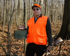
Great hiding spot! The ammo can and all contents were in excellent condition. After signing the logbook, I took two small foreign coins and left a Sacagawea dollar.
Having set waypoints for the singletrack trail we found earlier, our GPS receivers told us we were only 0.11 miles from the point where it intersected the woods road, so we made a beeline there and retraced our route back to the car. We didn’t see a single squirrel during the entire trip!
Thanks for a challenging and memorable cache hunt, and the long, invigorating hike. Cheers and happy caching …
~Rich in NEPA~
P.S. I’d like to come back with mountain bike and check out the gamelands further, especially for a ride on that sweet singletrack trail. The coordinates for the endpoints of that trail we followed are: N41°06.276′ W075°54.006′ (powerline end) and N41°06.455′ W075°54.184′ (woods road intersection).
Hi OB!
Happy New Year!
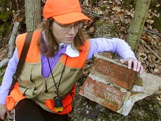
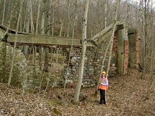
On our way home from our adventures nearby at “Bubbling Spring Multicache,” Rich and I talked ourselves into trying one more cache. We parked just off Route 309 and hiked down the long rocky slope toward the coordinates, passing all sorts of interesting ruins along the way. I really appreciated the historic perspective you provided on the cache page; it was nice to have that information available as we explored the ruins. So often we come across old foundations or other structures and have no idea of their former purpose.
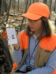
We found the necessary information easily and hiked quickly to the next set of coordinates so that we could put the clue to good use. It was a short walk and before we even arrived Rich was saying, “We’re headed due North, right? So that means that the cache is … ” “Oh, no!” We were already feeling beat from our adventures earlier in the day, but we continued and found the going slippery, but passable. Your chosen hiding spot was immediately evident, though retrieving the cache was a bit of a challenge (and probably would’ve provided an interesting photo opportunity if we’d thought of it at the time ![]() .) The cache was well stocked and in excellent condition. I traded a Disney stamp for a plastic letter stencil and signed the logbook around 3:30pm. While hiking back up the slope toward the car, we took a moment to photograph and record coordinates for a chiseled square (a surveyor’s mark) on a culvert over Pine Creek.
.) The cache was well stocked and in excellent condition. I traded a Disney stamp for a plastic letter stencil and signed the logbook around 3:30pm. While hiking back up the slope toward the car, we took a moment to photograph and record coordinates for a chiseled square (a surveyor’s mark) on a culvert over Pine Creek.
I could spend days exploring this area. (By now everyone probably knows how much I like finding abandoned structures in the woods.) Thanks for the opportunity to explore this important piece of our local history, and for sharing your knowledge and memories with us!
Zhanna
Howdy, OB!
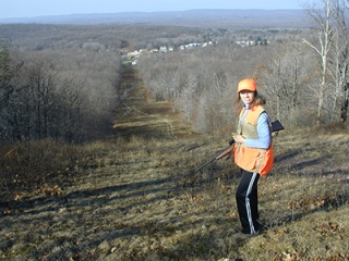
After completing a long and successful hike to “Bubbling Spring” and back, and then stopping briefly in Rita to check out a USGS benchmark from Zhanna’s datasheets, our route home on this incredibly warm New Year’s Day brought us past a small pull-off on Rt. 309 (southbound lane) that we knew would lead to the “Ashley Planes” cache. You were certainly right about all the “moogles” in this area. As you can see, we opted for the long hike downward along the old abandoned road bed.
We located the coal mining-era ruins where the clue for Part Two was easy to spot, and had some fun poking around, taking photos during the short period of time we spent there before moving on to the final cache. When we got to the second set of coordinates and turned in the direction indicated by the clue, we both let out an astonished, “Oh, no. Not there!” Our tails were kinda dragging by this point so the approach seemed a bit of a struggle. But we made it, in spite of the uncooperative footing conditions (don’t want to give too much away). This really is a very interesting spot and I would certainly love an opportunity to return and explore it more thoroughly. I couldn’t help wondering where some of those other roads might lead.
After signing the logbook, I didn’t take anything and left nothing (very unusual for me!). I was definitely feeling worn out from all of today’s intense activities, and we still had the long uphill trek back to the car. (Needless to say, I slept really well last night.)
From someone who’s extremely appreciative and respectful of the remnants of this area’s recent and colorful history, a sincere “Thanks!” for showing us another interesting place. We really did enjoy this well-executed Geocache hunt. Now, if only one of those old barneys would come chugging by and haul me back up to the top!
Cheers, and happy caching …
~Rich in NEPA~