About two weeks ago, Rich and I were on our way to Tanners Falls, and the geocache there, when we decided to change our plans and detour to Prompton Dam instead. Today we finally made it to the falls. And what a great day it was, warm (for Winter) and full of adventures!
Even the drive to the falls was exciting. It was my first time being guided by a Garmin iQue 3600, Rich’s new Xmas toy. There’s nothing quite like the peacefulness of driving on country roads punctuated by *Boing!* “In 300 feet, turn right.” Our first attempt to approach the falls was blocked by a Road Closed sign with, apparently, no road beyond it. We probably could have parked and walked down the hill, but we didn’t trust the neighbors to be friendly or forgiving, and we knew that it wouldn’t be necessary to trespass to reach the geocache anyway. We looked for another route and found easy access just another mile and a half south on Route 670.
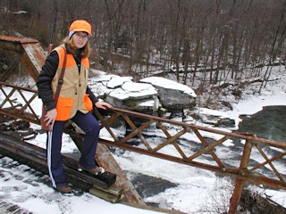
The falls were beautiful and half frozen when we arrived. We took a long slow hike over the bridge and up the hill, chatting and looking for squirrels as we walked. (A little squirrel did pop out of the woods at one point, but he was too quick for us.) Eventually we entered the woods and slipped and slid toward the cache! Wet leaves covered by slushy snow on a steep hillside makes for pretty slick conditions. The cache was hidden well—without being so hard to find that people would be tempted to tear the area apart.
If it had been warmer this would have been a perfect spot for a picnic! The sound of the rushing water was very soothing. We took a few photos and signed the logbook before heading off on the rest of the day’s adventures, which began with a long hike and squirrel hunt on gamelands trails alongside the creek. We were unsuccessful in our squirrel searching, but enjoyed the hike and the chance to learn more about the trails in the area.
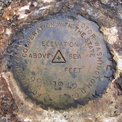
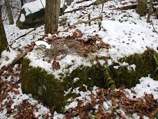
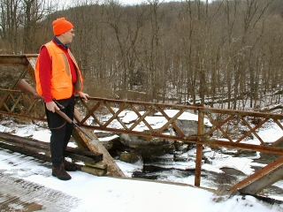
Just one more activity would make the day complete. My USGS datasheets indicated a chiseled square benchmark on the bridge over the falls. We found it easily and took photos (somewhat less easily). We then drove a short distance north to search for another mark near the East Branch of Dyberry Creek. The third mark I had planned for the day was closer to the falls, so we drove back the way we’d just come, driving over the bridge this time and heading toward the benchmark coordinates, or so we thought.
Where were we? Maps didn’t help, GPS didn’t really help. Nothing we saw on the maps seemed to match up with what we saw with our own eyes. At one point Rich brought out his handheld GPS to compare maps when we were unable to get a satellite lock with the iQue. My only regret is that I didn’t have my own new Garmin GPSmap 76CS, which was defective and had to be returned for replacement. With all three mapping units lined up on the dash we’d have looked like true techno-geeks fumbling about in the wilderness!!! (As it was, of course, two on the dash and my yellow eTrex in the cupholder only qualified us for semi-techno-geek status.) Eventually, we figured out that the road we wanted must have been the closed road we’d encountered earlier, and we couldn’t take it straight through to the mark. A detour around the “block” brought us right to the benchmark.
There’s plenty more exploring to do near Tanners Falls, and I can’t wait to return!
Today's Geocache
- Owner: unimoggers
- Location: N 41° 39.705' W 075° 18.024'
- Log Type: Found it
- Date: 30 December 2004
- Original Geocaching.com listing
Hi, UMs!
About two weeks ago, Rich and I were on our way to Tanners Falls when we decided to change our plans and detour to Prompton Dam instead. Today we finally made it to the falls. And what a great day it was, warm (for Winter) and full of adventures!
Even the drive to the falls was exciting. It was my first time being guided by a Garmin iQue 3600, Rich’s new Xmas toy. There’s nothing quite like the peacefulness of driving on country roads punctuated by *Boing!* “In 300 feet, turn right.” ![]() Our first attempt to approach the falls was blocked by a Road Closed sign with, apparently, no road beyond it. We probably could have parked and walked down the hill, but we didn’t trust the neighbors to be friendly or forgiving, and we knew that it wouldn’t be necessary to trespass anyway. We looked for another route and found easy access just another mile and a half south on Route 670.
Our first attempt to approach the falls was blocked by a Road Closed sign with, apparently, no road beyond it. We probably could have parked and walked down the hill, but we didn’t trust the neighbors to be friendly or forgiving, and we knew that it wouldn’t be necessary to trespass anyway. We looked for another route and found easy access just another mile and a half south on Route 670.
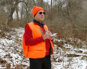
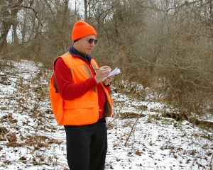
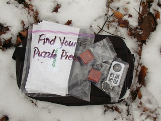
The falls were beautiful and half frozen when we arrived. We took a long slow hike over the bridge and up the hill, chatting and looking for squirrels as we walked. (A little squirrel did pop out of the woods at one point, but he was too quick for us.) Eventually we entered the woods and slipped and slid toward the cache! Wet leaves covered by slushy snow on a steep hillside makes for pretty slick conditions. The cache was hidden well—without being so hard to find that people would be tempted to tear the area apart. It was in fine condition. We found only a logbook and some leftover puzzle pieces inside, so we each added a few items for the next finder. I left two Disney character rubber stamps. If it had been warmer this would have been a perfect spot for a picnic! The sound of the rushing water was very soothing. We took a few photos and signed the logbook before heading off on the rest of the day’s adventures, which began with a long hike and squirrel hunt on gamelands trails alongside the creek. We were unsuccessful in our squirrel searching, but enjoyed the hike and the chance to learn more about the trails in the area.
Just one more activity would make the day complete. My USGS datasheets indicated a chiseled square benchmark on the bridge over the falls. We found it easily and took photos (somewhat less easily). We then drove a short distance north to search for another mark near the East Branch of Dyberry Creek. The third mark I had planned for the day was closer to the falls, so we drove back the way we’d just come, driving over the bridge this time and heading toward the benchmark coordinates, or so we thought.
Where were we? Maps didn’t help, GPS didn’t really help. Nothing we saw on the maps seemed to match up with what we saw with our own eyes. At one point Rich brought out his handheld GPS to compare maps when we were unable to get a satellite lock with the iQue. My only regret is that I didn’t have my own new Garmin GPSmap 76CS, which was defective and had to be returned for replacement. With all three mapping units lined up on the dash we’d have looked like true techno-geeks fumbling about in the wilderness!!! (As it was, of course, two on the dash and my yellow eTrex in the cupholder only qualified us for semi-techno-geek status. ![]() ) Eventually, we figured out that the road we wanted must have been the closed road we’d encountered earlier, and we couldn’t take it straight through to the mark. A detour around the “block” brought us right to the benchmark.
) Eventually, we figured out that the road we wanted must have been the closed road we’d encountered earlier, and we couldn’t take it straight through to the mark. A detour around the “block” brought us right to the benchmark.
Thanks so much for a very nicely done cache and for introducing us to another beautiful area in northeast PA. There’s plenty more exploring to do here and I can’t wait to return!
Zhanna
Howdy, UMs!
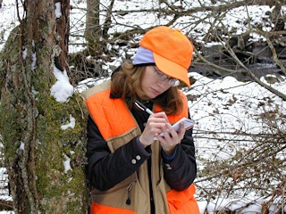
It’s only been two weeks since we did “Prompton’s Promise” but what a difference in the weather! I knew I wanted to get back to the area for this cache since we’d been so close last time, and now the conditions were so much milder—temps in the mid-30’s, overcast skies, and no wind at all. The plan was to do the cache and then hike the gamelands hunting for squirrels (it’s usually the hike that we focus on, mostly for the chance to become familiar with new trails; looking for squirrels, however, provides a challenging goal). Zhanna brought benchmark datasheets, too, and it’s good that she did. More on that later.
Zhanna drove today and picked me up around 9:30am. We loaded up her SUV and headed out, following the voice prompts from my brand new Garmin iQue 3600 vehicle navigation system. (I already knew the way, but I really just wanted to play with it! ![]() ) It automatically routed us along the very same roads we took to Prompton last time, and then around the north end of the dam toward a waypoint which, from the gamelands map I suspected was a good SGL parking lot near the cache. From Rt. 670 we were directed northeast along Kilroe Road. Well, Kilroe Road dead-ends less than ¼-mile from the parking spot, even though the maps showed it going straight through! We didn’t feel like parking at the barricade since all the property around here is heavily posted, so we re-routed ourselves south on Rt. 670, around and up to Tanners Falls, then west along Tanners Falls Road to the falls. Convenient parking was found right at the steel bridge. Later we discovered that it’s also possible to approach the falls from the north via Egypt Road off Rt. 670, a mile or so below the Rt. 247 intersection.
) It automatically routed us along the very same roads we took to Prompton last time, and then around the north end of the dam toward a waypoint which, from the gamelands map I suspected was a good SGL parking lot near the cache. From Rt. 670 we were directed northeast along Kilroe Road. Well, Kilroe Road dead-ends less than ¼-mile from the parking spot, even though the maps showed it going straight through! We didn’t feel like parking at the barricade since all the property around here is heavily posted, so we re-routed ourselves south on Rt. 670, around and up to Tanners Falls, then west along Tanners Falls Road to the falls. Convenient parking was found right at the steel bridge. Later we discovered that it’s also possible to approach the falls from the north via Egypt Road off Rt. 670, a mile or so below the Rt. 247 intersection.
The cache was an easy find, but the now-slushy snow on dead leaves made negotiating the hillside a bit of a challenge. The pouch was well hidden and the contents were in good condition. Nice hiding place! There were no trade items inside but quite a few puzzle pieces remain. We signed the log, and we left a few items to spur trading again. We stayed long enough for a few photos, amidst the roar of the falls not far away.
The remainder of our day consisted of a long there-and-back squirrel hunt along one of the trails leading from the bridge, north along the west branch of the Dyberry, and later the recovery of three USGS benchmarks. Zhanna was especially excited about finding the chiseled square on a pier of the bridge. Two more little bronze disks put a nice finish on our trip to Wayne County. Daylight was fading fast as we headed for home.
Much thanks for a VERY pleasant, fun-filled day, and the opportunity to explore a fabulous area.
~Rich in NEPA~