Today Rich was ready to tackle a slightly longer and more challenging ride. We have to prepare for our upcoming trip to Acadia! John met us at the house, then followed us along the winding back roads through Clifton to White Haven. Even with twists and turns and blind hills and the occasional driver flying toward us over the middle line, it’s still a very relaxing and peaceful route compared to I-81. And it’s like riding in a beautiful tunnel of fluttering green, at least in the summer. Somewhere along the way, Rich and I searched for gamelands that we swore we’d seen before, but we were unable to find the area.
The White Haven Bakery is “quaint”; that is to say that it looks old-fashioned and dull, but it seems clean and they make delicious goodies. There’s no seating, so we stood on the sidewalk and nibbled. Rich and I split a sticky bun (just sticky enough, nuts but no raisins!) and flaky apricot twist. John had an apple turnover. They both drank coffee. I just took a few sips from Rich’s cup. I admired the garden, intentional or not, of Lilliputian hens-and-chicks near the fence.
It’s typical on dam release weekends for the Lehigh Gorge access points to be insanely busy. So as we expected, the parking area was full of river rats. At least they wouldn’t be riding the trail! A woman mentioned that she liked my Team Moose jersey as I waited in line for the portapotty. “It’s custom made,” Rich said with a smile, and no further explanation.
Our ride was awesome, as always, but relatively uneventful. As the day went on the trail became busier, but not as busy as the river! We kept our ride a bit shorter than usual—to Rockport and back, 19 miles—but it was the longest post-surgery ride Rich has done to date. I’m so impressed! On our return, we rested, cooled off and snacked by the waterfall just north of Rockport. I think it’s become a tradition.
Next we went to the monastery to look for GREEN. Our luck? We had “nun.” I guess we should have attempted it while the place was still under construction/renovation, but Rich wasn’t up for the hike back then.
The monastery has come a long way since the last time we were up there. We marveled at the buildings roofed in bright Spanish tile and the whole layout of the property. I felt like I was in the southwest or on a Greek isle somewhere. After we passed the main building, we could see what looked like a clearing, possibly leading to a trail heading up the mountain, but there were signs in Greek and English saying that it was private and to pass required a special blessing.
We found a young sister coming up behind us and we asked what we would need to do if we wanted to hike up the mountain toward the cross. She said she could not give us permission but that she would go inside and ask someone else. After a few minutes she came out and said that she was sorry, but she couldn’t get permission for us. We thanked her, she blessed us—apparently not the special blessing—and we left soon after. (We later joked between ourselves that it was Rich’s fault because the nuns must have his poster on the wall from back when he was a bad kid in Catholic school. I know they’re not the same kind of nuns, but we still got a laugh out of it.)
So we set off toward the azimuth mark, on the other side of the river and south about a mile. The road was narrow, which concerned us a bit, but when we neared the coordinates we saw a convenient clearing along the western side of the road and, as luck would have it, a 9×5 foot boulder across and about 12 feet above the road, as described. Unfortunately, there were houses just beyond. I decided I would walk up the driveway, which would give me an easy view of the top of the boulder as I passed by. If I could see the mark and if I felt relatively secluded, I might just go ahead and take my photos and coordinates; otherwise, I would knock on the door of the residence to ask for permission.
As I hiked up the gravel driveway, I heard a dog barking. Shit. I went a little further and saw a man working on his truck. I got a hillbilly rocker vibe from his curly beard and lack of front teeth, but he turned out to be one of the nicest people I’ve met while benchmark hunting. He assured me that the dog was harmless (it did seem quite docile), and he asked where I was headed, assuming I was lost. I explained that I was actually there to document the survey mark on the big boulder alongside his driveway. He was thrilled to find out what the mark’s purpose was, having known about it for years (he said, in fact, that his grandfather would have been living there when the mark was set in 1958). I explained what an azimuth mark was used for and how it related to the GREEN triangulation station. He even got to hear the story of how we were denied the special blessing at the monastery.
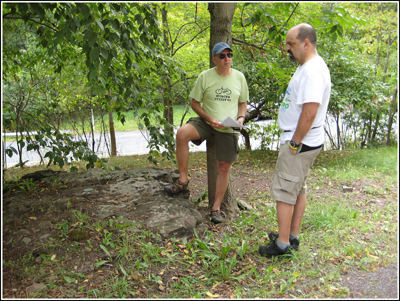
I motioned for Rich and John to come up and check out the disk while I took my photos. Rich explained a little about azimuth marks and survey mark hunting in general to John while I worked. When we were done, I went back to thank the landowner. He asked what he should do if anything ever happened to the mark, and I gave him the NGS contact information. In retrospect, I probably should have given him the datasheet, but we could always drop it off for him some other time when we’re in the area.
After all the action, we were more than hungry. We stopped at Carmine’s, a little family-owned pizzeria on Main Street. It was good, but the pizza tasted different from the last few times. We wondered if they’ve changed their recipe or if the restaurant changed hands. On the way home we passed the “Nites Inn,” apparently the new name for the horrendously disgusting White Haven Knights Inn where John stayed a few months back. Do they think a name change will fool anyone?!