Our trip to Storm King was the second in our late-Summer series of day trips to the Hudson Valley region. Tuesday night I had a terrible time deciding where I most wanted to go. Even a few hours spent sitting on the porch going over maps didn’t solve our problem, though by the end of the night I did finally narrow it down to two spots—Storm King and an area of the Catskills we visited last year. By morning, my mind was made up, and I think Rich was also pleased that we’d be visiting someplace new.
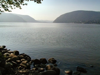
My first surprise of the day was our unanticipated stop at Plum Point. We decided to simply explore and enjoy the hazy sunshine rather than search for the geocache at Plum Point. Immediately we identified Storm King Mountain in the distance, a profile we’d become very familiar with over the last few weeks. After a few moments spent relaxing by the shore, we headed to our main destination.
Following a hike description that Rich had found online, after a brief mistaken detour into the woods on an unmarked trail, we set out from the parking area “along the grassy shoulder of the road”. Seeing not a single yellow blaze, we kept walking and walking. When we hit Mountain Road we knew we’d gone way too far and turned back. The hike back up that hill wore us out prematurely! Finally back at the little patch of woods near the parking area, we spotted the yellow (actually orange) blazes. Oops. Apparently on our little detour into the woods we’d walked behind the blazed tree, come out on the west side and, not seeing anything, continued even further west. Don’t make this mistake! We returned to the car for a drink and to start over as if nothing had gone wrong.
The yellow trail climbs very steeply and took us to a rock ledge overlooking Route 9W. From there we headed steeply upward again and soon came across three stone pillars and part of a granite foundation—ruins of Spy Rock House, according to our hike description. What a place for a Summer home!
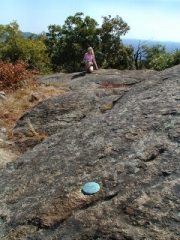
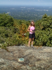
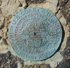
Our next stop was the summit of Butter Hill. I wasn’t prepared for the sight. Not only do the 360° views make this a perfect spot for a triangulation station (BUTTER HILL RESET, LY2493, which we recovered), but it’s also one of the most inspiring geocache locations I’ve visited. We gathered our documentation for the station first, and then searched for the Butter Hill South geocache. It was well hidden, but the coordinates took us right to the spot. Everything was in fine shape inside. Back at the tri-station we spread everything out in the sunshine, looking leisurely through the contents and writing our logs.
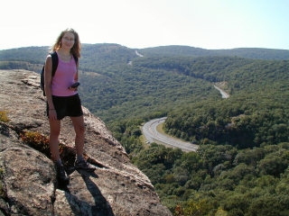
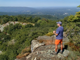
We continued along the trail looping up to the summit of Storm King Mountain itself and then down to the blue-blazed Howell Trail, stopping at each overlook along the way (each seemed better than the last—really!). Rich pointed out the easily recognizable features of the Shawangunks which we could see about 25 miles distant, and I told him what I knew of Bannerman’s Castle, situated beneath us in the river on Pollopel Island. Binoculars are a must!
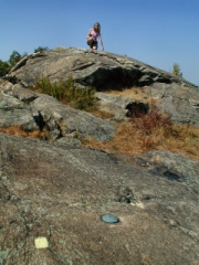
The Howell Trail took us south to the Stillman Spring Trail, which we began following northeast. This is where our mile-long walk along Route 9W caught up with us. We were worn out, hot, sweaty and our knees were killing us. We turned around and instead took the Howell Trail up to North Point. That’s as far as we got. Time to turn around for good, but not before finding a slanting slab overlooking the river where we could rest for a while in the sun—a rewarding end to an exciting hike. Our return trip had us briefly confused about the location of Clove Road, which we finally found and followed out toward the parking area—emerging from the woods on the unmarked trail we’d seen on our accidental “detour” into the woods upon our arrival.
Today's Geocache
- Owner: jonboy
- Location: N 41° 25.619' W 074° 00.054'
- Log Type: Found it
- Date: 17 August 2005
- Original Geocaching.com listing
Hi, JB!
Our trip to Storm King was the second in our late-Summer series of day trips to the Hudson Valley region. Tuesday night I had a terrible time deciding where I most wanted to go. Even a few hours spent sitting on the porch going over maps didn’t solve our problem, though by the end of the night I did finally narrow it down to two spots—Storm King and an area of the Catskills we visited last year. By morning, my mind was made up, and I think Rich was also pleased that we’d be visiting someplace new.
My first surprise of the day was our unanticipated stop at Plum Point. We decided not to worry about the cache today, but rather to just explore and enjoy the hazy sunshine. Immediately we identified Storm King Mountain in the distance, a profile we’d become very familiar with over the next few weeks. After a few moments spent relaxing by the shore, we headed to our main destination.
Following a hike description that Rich had found online, after a brief mistaken detour into the woods on an unmarked trail, we set out from the parking area “along the grassy shoulder of the road”. Seeing not a single yellow blaze, we kept walking and walking. When we hit Mountain Road we knew we’d gone way too far and turned back. The hike back up that hill wore us out prematurely! Finally back at the little patch of woods near the parking area, we spotted the yellow (actually orange) blazes. Oops. Apparently on our little detour into the woods we’d walked behind the blazed tree, come out on the west side and, not seeing anything, continued even further west. Don’t make this mistake! We returned to the car for a drink and to start over as if nothing had gone wrong.
The yellow trail climbs very steeply and took us to a rock ledge overlooking Route 9W. From there we headed steeply upward again and soon came across three stone pillars and part of a granite foundation—ruins of Spy Rock House, according to our hike description. What a place for a Summer home!
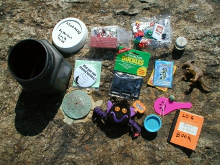
Our next stop was the summit of Butter Hill. I wasn’t prepared for the sight. Not only do the 360° views make this a perfect spot for a triangulation station (BUTTER HILL RESET, LY2493, which we recovered), but it’s also one of the most inspiring geocache locations I’ve visited. We gathered our documentation for the station first, and then searched for your cache. It was well hidden, but the coordinates took us right to the spot. Everything was in fine shape inside. Back at the tri-station we spread everything out in the sunshine, looking leisurely through the contents and writing our logs. I left a small Lego set and took a plastic cow from the bag of barnyard critters.
We continued along the trail looping up to the summit of Storm King Mountain itself and then down to the blue-blazed Howell Trail, stopping at each overlook along the way (each seemed better than the last—really!). Rich pointed out the easily recognizable features of the Shawangunks which we could see about 25 miles distant, and I told him what I knew of Bannerman’s Castle, situated beneath us in the river on Pollopel Island. Binoculars are a must!
The Howell Trail took us south to the Stillman Spring Trail, which we began following northeast. This is where our mile-long walk along Route 9W caught up with us. We were worn out, hot, sweaty and our knees were killing us. We turned around and instead took the Howell Trail up to North Point. That’s as far as we got. Time to turn around for good, but not before finding a slanting slab overlooking the river where we could rest for a while in the sun—a rewarding end to an exciting hike. Our return trip had us briefly confused about the location of Clove Road, which we finally found and followed out toward the parking area—emerging from the woods on the unmarked trail we’d seen on our accidental “detour” into the woods upon our arrival.
Your cache served as a fine introduction to Storm King. We both loved the trails and the views and plan to return soon. Thanks for maintaining your cache here and seeing it through all the park’s troubles!
Zhanna
Howdy, JB!
Let me start by saying I can find only one word to describe Storm King Mountain: “Awesome!!!” Zhanna and I got together last night over sweetcorn and broiled Haddock (thanks to chef Aaron!) to plan a day-trip for Wednesday. It was a toss-up between a visit to the North-South Lakes region of the Catskills, which we haven’t done since last year, or visiting someplace that was new to both of us. We left the final decision for morning, when I picked Zhanna up at her place, and without any further discussion Storm King Mountain won out. Last Wednesday we drove to State Line Lookout and did an 8-mile trek through the New Jersey Palisades. The views there were spectacular and we vowed to come back to the Hudson River Valley again. We were certainly glad we did!
During a brief mid-morning stopover at Plum Point in order to introduce Zhanna to a pleasant little park and a fine view of the Hudson River (I found the cache that’s there several years ago), we marveled from a distance at the looming expanse of our destination—Storm King Mountain. Then, arriving at the Stillman Trail parking area off Route 9W (N41° 25.385′ W074° 00.035′) we got off on the wrong foot by following too literally a hike description I’d printed from the Web last night. Unknowingly we passed the trailhead while walking too far along the shoulder of the highway north. Finally we were on the right path to Butter Hill (new blazes are more like orange than yellow). Along the way we checked out the ruins of Spy Rock House, which (I learned from my printout) was the summer cottage of Dr. Edward L. Partridge, who served on the Palisades Interstate Park Commission from 1913 to 1930. We also pondered the question of how he would have gotten back and forth from here, since there was no evidence of a road leading up to the place!
Shortly afterwards we reached the apex of Butter Hill where we were greeted by one of the most spectacular views of the day. The 360° panorama was breathtaking. It’s easy to see why someone chose to put a benchmark here! We performed our standard recovery of the NGS tri-station then went over to search for the cache. Looks like we’re the first to find it since last year. I feel honored! Thankfully, the “unexploded ordinance” threat has been abated and this park is now fully open again. Your cache was well hidden and in good condition. After signing the logbook I added a novelty magnet and a Fastex buckle set; didn’t take anything.
We continued our amazing journey to the summit of Storm King Mountain, stopping for a time at each of the overlooks. If you’re reading this log and haven’t been to Storm King yet, don’t forget to bring your binoculars! The birds-eye view of Bannerman’s Castle on the Hudson is especially neat. As is being able to take in the broad spectacle of the Shawangunk escarpment extending from Sam’s Point and Minnewaska S.P. to Mohonk Preserve and Skytop, two dozen miles away, and behind that the high peaks of the east Catskills at twice that distance! We looped around and down to the Howell Trail, where we climbed a ridge trail as far as North Point overlook. That’s when I decided to call it quits. The Storm King had whipped me! We were worn out enough by then to realize we wouldn’t be doing the entire loop of the Crow’s Nest section, so after having a snack and spending some time reclining on a rock slab in the fading sunlight, it was time to head back to the car and home.
The final overall highlight in today’s adventures was that we observed no poison ivy, and no ticks. It was so nice for a change to have such peace of mind on a long hike! Thanks for providing us with an opportunity to experience this incredible and memorable preserve. We hope to return very soon.
~Rich in NEPA~