No. 1
This is our third consecutive weekend visiting the Waymart area for USGS benchmark hunting (… and pizza and BBQ from the Waymart Hotel). We haven’t come close to finding all of them yet! This area is rich in benchmarks, and also rich in railroading history. For years, Rich and I have read everything we could find about the local gravity railroads and have explored many of the old lift planes and structures of the Pennsylvania Coal Company’s gravity railroad on the Moosic Mountains near Dunmore. The last few weeks’ explorations have put us further east, in the territory of the Delaware & Hudson’s gravity railroad. I was so excited to see a benchmark description that actually mentioned the D&H Gravity and referred to the ice trade on Keen Lake. I spent the week in anticipation, fully aware that the area is now full of cottages and campsites. I didn’t really expect we’d find anything, but I had to look.
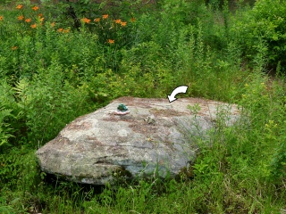
This morning, we made Keen Lake our first stop. We parked on North Elk Forest Drive, just about 100 feet from the coordinates I had pulled from the topo map. As we approached the house to the north of the road, we could see the large boulder that we suspected held the mark. No one was home, so we made our way through the yard (carefully avoiding the poison ivy that infests this entire area) toward the boulder. Rich laughed when he saw a small figurine of a frog perched on the highest point of the boulder. “I bet it’s underneath that frog!” he said. I had the same idea, but when I climbed up onto the boulder I cold see that the mark was set right in the middle, a few feet away from the frog. I brushed off the pine debris and found the disk, TT 14 T, in perfect condition underneath.
Although the disk is in excellent condition, Rich and I had to wonder why it was set into this boulder that appears to be sitting right on the surface of the ground rather than an embedded boulder or outcropping bedrock, as it typically used. I’m still going to call the condition “good” but with the caveat that I don’t know how much the boulder might have moved since the mark was set. The coordinates I recorded at the spot were within 20 feet of the coordinates I estimated from the topo map.
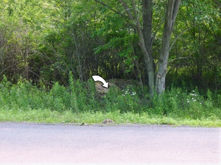
Little is left of the gravity railroad in this area. One structure can be seen clearly from Route 6: Gravity R.R. Structure on Keen Lake
No. 2
TT 13 T was next on our list after our success at nearby Keen Lake. As we drove by the coordinates I had estimated from the topo map, all we could see was swamp—in fact, deep standing water, and no sign of a large rock outcrop. The description was vague, too. The situation required in-person investigation.
Rich parked at the intersection of T 435 (Layton Road) and Tuthill Road. As soon as I walked a few yards northeast along Tuthill Road, I could see a large rock outcrop east of the road, just inside the tree line. Unwilling to wade through the weeds, which most certainly contained poison ivy (of course), I scouted the rock outcrop with the help of binoculars. I still couldn’t see a disk, but with no other outcrops anywhere nearby, I was sure this was the correct one. I took a chance and picked my way delicately through the weedy border (which did contain a small amount of P.I., but a much larger quantity of dewberry). I was soon standing right over the mark. It was well camouflaged, but easily spotted from just a few feet away.
The disk is in excellent condition and is solid in its setting in the outcrop. It is easily accessible so is probably a good choice for surveyors to use. We didn’t, however, see any indications of recent use like nearby flagging tape or paint.
No. 3
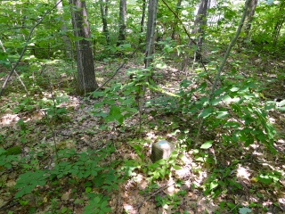
Our third mark for today, TT 19 T, took us on a winding country road adventure. The panoramic views of the windmills from Robinson Road were a real treat! Much of the description is long out of date, but we trusted that the coordinates I’d pulled from the topo map would get us within twenty feet of the mark, as they typically do. We drew close to the coordinates and found ourselves nearing the base of a gravel driveway, with a wooded patch to the north. We drove by slowly, not expecting to see much from the road. But in an instant, we both spotted a yellow-painted post several yards into the woods!
We parked and walked up the driveway to find a bare-chested man watching us warily. I think he had an eyebrow raised—maybe he thought we were selling something. Fortunately, he was very friendly, knew exactly where the mark was, and was excited to show us. We told him we had already spotted it from the road and just wanted permission to enter the woods and take a few photos. The man said, “Sure, absolutely, go ahead!” and then went on to tell us that we weren’t the first. A few years ago, some other people had stopped by to check on the mark. They spent a few minutes in the woods just verifying the mark’s condition, he assumed, and then they left. Rich and I are still wondering who they might have been! PennDOT, or maybe someone from USGS? It’s highly unlikely that a geocacher would know about this mark, since it’s not in the NGS database, but I suppose it’s remotely possible.
The disk and monument are in near-perfect condition. They have a good caretaker who, he said, clears the area of excess growth because he recognizes the importance of the mark. We showed him the description, but he was unfamiliar with some of the older landmarks mentioned, like the Arnold farmhouse and the Spangenberg School.
No. 4
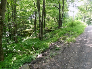
Even though we didn’t find the final mark we had planned for today (TT 16 T), we had a great time searching! This was our fourth and final targeted mark for the day, and it worked out well because Flat Rock Road provided a nice back route home from Waymart. In fact, neither of us had ever driven on this narrow, winding gravel road before, so even that was an adventure. When we approached the coordinates, we spotted the 12 foot high outcrop immediately, even though the forest is now swallowing it up. “This is neat!” Rich exclaimed as we picked our way across the top of the outcrop. It certainly was. The high ledges gave us a nice view through the thick forest, and the outcrop would make a pleasantly shaded picnic spot. We identified two sections of ledge that appeared to be likely benchmark locations, but the areas were large and without a metal detector, it might have been hours before we uncovered the mark from beneath heavy leaf litter and pine debris. We plan to come back soon with our metal detector (and some “gardening” tools) and search again.


