“Subdued” is a good description of this year’s Death Hike (as much in opposition to the term “Death Hike” as that may sound). That was fine with both me and Ken, since we both have been swamped for over a year with various projects. A simple, relatively quiet hike in the woods was exactly what we needed.
Last year, Ken’s wife Gina was sick and had to miss the Death Hike. Consequently, I missed out on the awesome breakfast she typically makes for us before we head out on the hike. This year, Gina was injured and again would not be joining us, but I was determined to drive down to their house, no matter how long it took or how early I had to get up, just to enjoy the meal.
But the more I thought about it, the driving distances and times were just unreasonable, particularly considering that I would have to make the same long drive in reverse at the end of the day. So I decided to drive directly from home to Ricketts Glen (of course, inserting a few benchmark hunts along the way) and wait for next year to enjoy Gina’s delicious breakfast scramble. Not going to lie, it was a difficult decision!
Just like last year, I left our house at 7:00am and took the back roads through Tunkhannock, Noxen, and Sweet Valley on my way to Ricketts Glen. Unlike last year, which was a beautifully sunny, warm morning, today was cool and cloudy with the threat of impending rain.
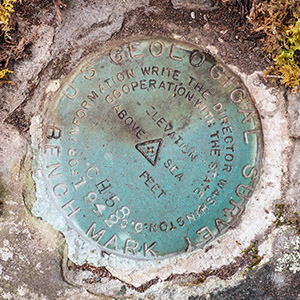
The first benchmark I searched for, a USGS mark from 1942 designated 58 CH, turned out to be the only one I found this morning, despite having high hopes for several marks in the area.
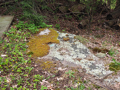
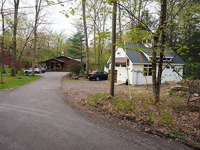
While doing my research from home, I had noticed that a “large flat rock” (as mentioned in the mark’s description) is visible on Google Street View, and I suspected this was the rock that held 58 CH. I was pleased to see that this guess was correct. I parked at the nearby Cottage in the Woods Bed & Breakfast, which was calm and quiet this early morning. Then I walked up to the rock, where I immediately spotted the blue disk poking out halfway from underneath a mat of yellow moss. Somewhat interestingly, the stamped designation is actually CH 58 rather than 58 CH. I did not search for 58 CH’s reference mark today. There is a drainage ditch that flows beneath a side road at approximately the distance given, but I didn’t see a stone culvert anywhere in the area.
Moving on, I drove to a mark I had on my list last year but did not have time to search for: 51 CH, another USGS mark that had been set in a church yard nearby. Unfortunately the yard is completely covered with grass and there is no sign of a rock outcrop.
We were planning to meet this year at the Lake Rose trailhead, rather than the Route 118 trailhead where we met last year, so I planned to search for a few marks along the road that would take me toward Lake Rose. These were also a bust, but they might be worth another try in the future (particularly TT STA NO 24 B), when I have more time to explore.
As it was, time to myself this morning was growing short. It was already 9:15am, and we were to meet around 9:30am (and I always like to arrive early). I pulled into the parking area for the Lake Rose trailhead, a little concerned about how busy it might be on a spring Saturday, but the lot wasn’t yet half full, and I found a corner spot in the lot.
Within a few minutes, Ken pulled up and parked next to me, just as I was setting up my tripod for the group photo—assuming there even was going to be a group! We had our doubts, because while although most years the students express a lot of interest when Ken mentions the hike in his classes, this year the response was … crickets.
But we knew we could still rely on Alan, right? Ol’ Reliable Alan is the most die-hard member of the lifetime Death Hike crew (aside from me, Ken, and Gina, of course) and even though he may disappear for the rest of the year, he is somehow summoned from the depths of New Jersey and appears at the proper date, time, and location each year for the Hike.
But where was he? Before Ken arrived, I had taken a quick run through the parking lot looking for Alan, his Subaru with New Jersey license plates, or anything resembling the above. Nothing. Hmm. Wouldn’t surprise me if Alan went to the Route 118 lot, where we began the hike last year.
Anyway, Ken assured me that one of his current students, Liam, was really into hiking and backpacking and was almost certain to join us. Which he did, within a few minutes. No one else showed up, although we waited until just past 10:00am. We shrugged, took the (very small) group photo, and headed off on the Highland Trail.
We would be hiking clockwise, following the Highland Trail to the eastern side of the Falls Trail, which we were unable to hike last year due a rockfall that closed the trail for several months. We would continue clockwise from Waters Meet up the western side of the Falls Trail—a section we’d hiked last year, not that I minded the repeat.
The Highland Trail is relatively level and very easy walking. Soon we came to a labyrinth-like feature of enormous boulders and rock ledges and crevasses known as Midway Crevasse, according to the map and a sign at the site.
“Wow, this is massive!” exclaimed Liam.
“A massive crevassive!” I replied, and that goofy phrase somehow became the motto of today’s hike.
(Well, that and another phrase that I will mention below.)
As we clambered around on the Pocono sandstone conglomerate, Ken suddenly heard a “ding!” from his phone. “Oh, it’s a text message,” he said. “I must have just gotten a signal.” (This area is notorious for having almost no cell service.) But he didn’t recognize the number. The message read:
"Hey are we still doing the Death Hike? I got here at 9:15, no one's here lol"
After much back and forth, trying to text and call the number, and trying different phones, we eventually determined that, yes, it was Alan! And he was here for the hike, as expected. But he had, in fact, gone to the Route 118 parking lot rather than Lake Rose.
We were already two thirds of a mile into our hike, and Alan was at the bottom of the gorge and about 15 minutes away by car. But you can always use math to your advantage, right? So Ken texted back:
"If you drive up and do it counterclockwise we will meet by intermediate value theorem"
and that is indeed what we did!
Following an ultramarathoner will usually result in a rapid hike, so I don’t usually have the same photo opportunities on the Death Hike as I do when hiking alone or with Rich. But it’s still fun to take some snapshots here and there of the waterfalls, of course (which are true spray-and-pray snapshots, because waterfalls almost never look good without a longer exposure and the camera on a tripod). And I always explore the ground for smaller points of interest, which are typically provided by wildflowers at this time of year. The first weekend in May seems to be prime trillium season here at the Glen, and I found quite a few while we hiked.
The waterfalls on the eastern side of the Falls Loop are fewer and somewhat less impressive than those on the western side, but this means that the eastern side attracts fewer people, and thus makes for a much more peaceful experience.
We enjoyed Liam’s tales of hiking the Florida Trail, which included being kicked off the Seminole reservation for illegal camping, and meeting a man on Thank God Island who arrived carrying his food for the journey in a “crotch pot.” We were simultaneously repulsed and, of course, extremely curious about this. Liam reported that the crotch pot was indeed as gross as it sounds.
Alan met up with us not long before we reached Waters Meet, so he had certainly been hiking quickly himself (no doubt a result of the working out and playing hockey 5 days a week that he told us all about while we hiked). It was fun to catch up (literally!) with one of the veteran Hikers and hear about his adventures over the past year.
The western side of the loop was packed with people, as expected. We enjoyed the climb and the waterfalls along the way, but we didn’t linger as long as we did last year in any one spot. Although it was a short hike and a relatively easy one, we were all feeling hungry for pizza, and we had quite a drive to reach the pizzeria!
Back at the parking lot, we took our usual post-hike group photo, noting that this was the first time we’ve picked up an extra person along the way! And then we made sure everyone understood the directions to the pizza place, which was King’s in Mountain Top, just like the last two years.
Ken arrived before me at King’s—no surprise since he is a much faster driver than I am ![]() —and I parked next to him. This restaurant is huge and has about eight different rooms, plus an outdoor seating area. I had no idea where Ken was, but I checked the downstairs rooms where we had eaten the last two years. He wasn’t there. I texted him “Where are you?” and the response was “Inside.” Not helpful!
—and I parked next to him. This restaurant is huge and has about eight different rooms, plus an outdoor seating area. I had no idea where Ken was, but I checked the downstairs rooms where we had eaten the last two years. He wasn’t there. I texted him “Where are you?” and the response was “Inside.” Not helpful!
But the hostess saw me wandering around and pointed me to the front room, where Ken was waiting. And Gina was with him! She had driven up to join us for pizza. Liam and Alan arrived a few minutes later, and we ordered up our iced tea and coffee and began the process of figuring out our pizza toppings.
Pizza options always include the Monks Special (sausage, mushrooms, and onions) and at least a few plain slices. But this time Liam and Alan were interested in something new: ham and pineapple. I said I would happily try a piece, since I’ve never had it. Ken and Gina’s Italian heritage was offended, and they refused to call that particular one “pizza.” ![]() But I rather liked it. I don’t know that the toppings really meld with the flavors of the tomato and cheese, but they did taste good, and I would probably get it again sometime. (I am allowed since I have no Italian heritage whatsoever.)
But I rather liked it. I don’t know that the toppings really meld with the flavors of the tomato and cheese, but they did taste good, and I would probably get it again sometime. (I am allowed since I have no Italian heritage whatsoever.)
Although the skies had threatened rain all day, the only rain I encountered was a brief shower just as I left King’s. Another successful Death Hike—Let summer begin!


