We had enjoyed Jeannie’s so much for breakfast that we had to go once more before heading home. We spent the early morning packing up and getting the car ready, so by the time we arrived at Jeannie’s, the place was already full. We stood in the courtyard while we waited. “Eat. And. Go.” we kept saying, in the hope that we could somehow telepathically convince the diners to get their butts in gear and move on. ![]()
Breakfast was filling enough that we knew it would keep us going all day. I had a bowl of fresh fruit with yogurt and granola, and a slice of oat toast, while Rich had an order or pancakces with bacon. We shared a plate of corned beef hash. To drink, we had cranberry juice and Rich also had coffee.
It was a beautiful, sunny morning, and we had two more activities on our list before leaving town: searches for two very interesting triangulation stations at the northernmost tip of MDI.
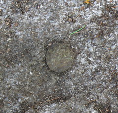
RICHARDS 1865 has to be one of our most exciting and intriguing finds yet! This station was considered Lost in 1934, when a racetrack was built at the site—in fact, the recovery note from that year sounds quite definitive when it states that “the station has been destroyed.”
The next recovery note, though, from 1944, gives some hope: STATION WAS SEARCHED FOR BUT NOT FOUND. AS THERE ARE MANY ROCKS IN THIS VICINITY, THERE IS A POSSIBILITY THAT THE STATION IS STILL THERE.
This statement was more than enough to entice us to search for the mark ourselves this morning, as we headed out of town. And believe it or not, the adjusted coordinates took us directly to the station mark! The rock outcrop in which the bolt is set was covered with moss, and the entire area is overgrown and difficult to maneuver in, but overall, it was a relatively easy find at Campground C-20! We couldn’t get over how cool it was that a mark set almost 150 years ago using the technology of the time was lost over the decades and then only found again by using the GPS technology of today. It’s a real testament to how accurate those original coordinates were (and subsequent maintenance adjustments have been)!
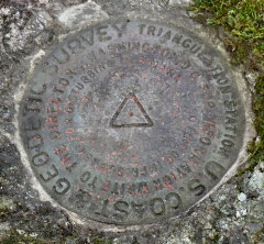
After that thrilling discovery of a station that had been considered lost for 73 years, we just had to stop for one more before heading home. HADLEYS POINT was a great choice because it’s so close to RICHARDS, and it was another very old station that we had been interested in for some time. HADLEYS POINT was last recovered in 1979, so it’s been a while since this station was visited, and we hoped to be able to provide an update.
While this station is very close to the campgrounds at Hadley’s Point, it is technically on private property not belonging to the campground. At no time did we feel like anyone would give us any trouble for poking around there, though. The station mark was an easy find, set in a rock outcrop at the base of a tree. It is a standard disk rather than a bolt, as noted in the 1979 description. From the stamping on the disk (HADLEYS POINT 1865 1934), it appears that the bolt was replaced by the disk in 1934, but curiously the 1934 description mentions the bolt and does not say anything about replacing it with a disk.
Both reference marks are set on large boulders in a wooded area near the station. They were easy to find and are also in good condition.
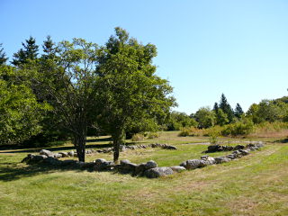
There is an old foundation near the station and for a few minutes, I wondered if it might have marked the site of Abraham Richardson’s house mentioned in the 1865 description. It’s in the wrong direction from the mark, so I assume it was not the same building, but it nevertheless lent an interesting historical aspect to this hunt! If only we could find out what it was.
These two station recoveries were by far the most exciting part of our day (other than, possibly, collapsing into bed once we finally returned home after a long, crazy drive through New England). We stopped twice along the way: once at one of the usual I-95 rest areas in Maine, and once at a bizarre McDonald’s in Connecticut where we legitimately suspected that we had entered the Twilight Zone.


