First, the bad news: our first benchmark hunt of 2016 didn’t result in a find. But the good news: it was nice enough for a survey mark hunt in January!
A few days ago dad suggested that we join him on a trip to Tunkhannock for Jeff Mitchell’s yearly presentation of Pennsylvania hiking photos. We expected chilly but sunny conditions, so we planned to make a full day of it. Breakfast? Of course—can dad pass up a chance to try a new diner? We ate at the Yearbook Diner—the new incarnation of Beagles Pub—on Tioga Street (the main street through Tunkhannock’s shopping district).
I wasn’t sure what to expect when we walked in. The room was a cross between an old-fashioned family restaurant and, well, a pub. I felt immediately at home surrounded by lots of flannel; what can I say. The locals seem to love it, and it was soon apparent why. Dad and Rich both had pancakes (blueberry for dad)—and while the cakes were light and flavorful, what sealed the deal for Rich was real butter and real maple syrup! It’s harder to find than you might think, which is especially sad in the Northeast. I had a wrap filled with fluffy eggs, just enough creamy cheese, and plenty of veggies, some of every variety they had in the kitchen. The green peppers and mushrooms went especially well with the eggs. (I confess that my craving for an eggy wrap was probably brought on by our discussion in the car of McDonalds’ sausage & egg burrito. They are pathetic and yet so tasty at the same time!)
We took our time eating, but we still had an hour and a half to explore the area before the presentation. We decided to use that time to walk down to the railroad tracks to search for the benchmark.
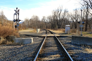
There were two ways to approach the mark, both of which would have provided a decent walk. We chose to walk down toward the big bridge over the Susquehanna River. Just before crossing the bridge, on the south side of Route 6, a narrow lane leads off to the west, parallel to the tracks. My initial impression was that the railroad was nearly untouched from the old days. Through the brush and trees we could see an old brick building that might have been an old freight station or some other operation connected to the railroad. It seemed entirely plausible that an old signal base might still be intact. Walking west, we passed a busy gym and a pleasant riverside park and after two thirds of a mile reached the end of the paved lane. From here we walked toward the tracks and approached the general location of the mark.
But as we approached the road crossing, our hope faded. The crossing was obviously quite new and no older structures were to be found along the tracks, which we walked for the last hundred yards or so, just to be sure we didn’t miss anything. We also noticed that the tracks sit atop what appears to be newly-laid ballast rock. And when we read over the description again, we noticed that it clearly refers to the “west-bound track,” implying that there were at least two sets of tracks when the mark was set. Now there is only one. Could this mean that we weren’t looking in the correct spot after all? Possibly! We did make an interesting find as we walked up the switchback road toward the highway underpass: there is a clear grade parallel to, and higher than, the current tracks. Could this have been the original railbed, or the location of at least the west-bound track, before the construction of the highway? It’s certainly possible. We walked along the grade for a few hundred feet until it became nothing more than a game trail through heavy brush. We saw no signs of structures or foundations alongside the higher grade.
In any case, it’s pretty clear that the old semaphore base no longer exists (at least not in any location that we can see or access). We decided to check PennPilot at home and see if it could shed any light on the situation. If we gleaned any information, we could always come back. While we poked around in the area, we were treated to a train (really just two engines), horn and all, crossing gates down, and a friendly engineer, passing by on its way west toward the Vosburg Tunnel.
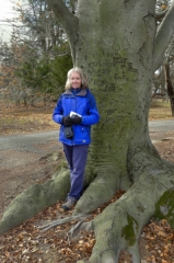
We made a loop out of our walk by heading back via the other route to town—through the highway underpass and north on West Street back to West Tioga Street in downtown Tunkhannock. Along the way east toward the theater we passed a huge old tree, which dad correctly identified as a beech, that impressed us all.
The theater was nearly full for the hour-long slideshow, and we enjoyed it as much as we had in the past. This year Jeff had all new photos to share, and the improvement in his composition skills was obvious. Featured natural areas were Bilger Rocks, the Black Forest Trail, and State Game Lands #57 in Wyoming County. For more, see Jeff’s website Endless Mountains Experience.
Lunch at Twigs was tasty as always! Rich and dad both had the Tuscan Garden Chicken Panini and I had a special, the cranberry turkey wrap. The sandwiches are large and filling enough that we almost always bring half home for later. Rich and I each enjoyed a beer from local brewery Nimble Hill while dad, who was driving, had iced tea.
Our return trip took us through Susquehanna County (“why are there no signs leading to Hop Bottom?! Doesn’t everyone want to go there?” “I think everyone already knows how to get there!”) and under the Nicholson Bridge before returning home to a sunny warm afternoon with sunshine streaming through the windows.
