Breakfast before today’s trip to Eastport was at 2 Cats: I had my usual granola and Rich had the Ho Hum (eggs over medium, home fries, plus bacon) and tea and coffee (again, it’s not “awesome” that we ordered coffee! This waiter must be the brother of Chatty Charlie from Jordan Pond House).
Mooses travel to Eastport
We left Bar Harbor around 8:30am and headed northeast along the coast toward Eastport. This is the first time we’ve ventured farther from MDI than Blue Hill. Other than the rear gate on the car not wanting to close at the rest stop, the drive went smoothly.
It may not appear on the map to be an impressive distance, but the trip took nearly three hours. The fog grew dense as we headed northeast along Route 1 through all the small villages and towns, many of which were barely towns—some were no more than a few houses grouped together. This is what stereotypical Maine looks like, at least in my mind! Only fields of lupines, a June-blooming flower that’s long gone by September, could have enhanced the Maine-like mood.
Finding the Equator Stone
It took nearly three hours, but eventually we found ourselves at the “Equator Stone” in Perry. I had seen this on a postcard months ago and it’s what first captured our interest about this area. The stone marked (or perhaps I should say “represented”) the 45th parallel—halfway from the equator to the North Pole. As survey mark hunters and map enthusiasts, Rich and I were naturally quite excited to see the stone.
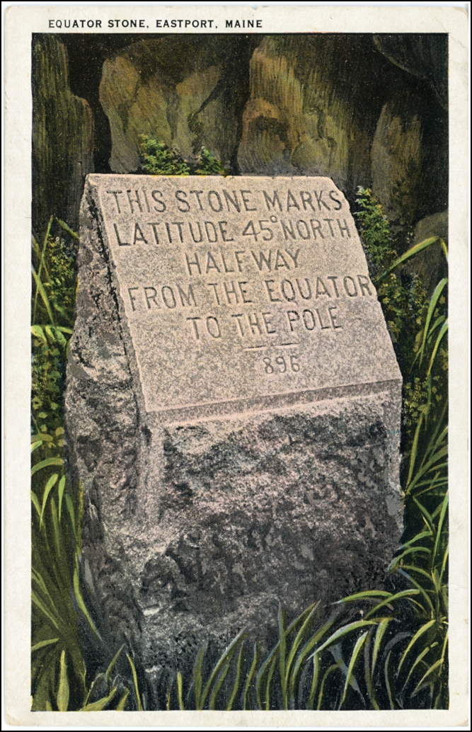
The story is that the mark first set by the original USC&GS surveyors was a bronze marker possibly similar to modern benchmark disks or bolts, but was considered a temporary marker and set as such. After several years, there was concern that the mark, and thus the surveyed location, would be lost so a permanent marker was set up in the form of the red granite monument we see today.
The following site annotates the story with some pertinent points and questions, such as “where is the original bronze marker,” and “what is the history of the location(s) of the stone” which we know to have been moved at least once? See THE HALFWAY MARKER
We noted that according to our GPSr, the stone’s coordinates are 44.9997051°N, -067.0887218°W. Not exactly 45 N, but pretty damned close!
Speaking of locations, we were continually reminded by T-Mobile how close we were to Canada, or at least Canadian cell towers, by the text messages I kept receiving welcoming us to Canada and then welcoming us back to the US as the signal bounced around. The sun was out while we poked around near the monument and the adjoining small patch of woods.
From Perry to Eastport, on Moose Island, it’s a straightforward drive southeast along Maine Route 190. We passed through the Pleasant Point Passamaquoddy Reservation on the way. Our route took us directly to the downtown but to our surprise, there really wasn’t much to see there. Part of the problem was that the summer season had, at least in Eastport, just ended. That meant that some of the restaurants, including the Moose Island Bakery, that we were interested in trying were already closed for fall.
Amazing lobster rolls
As the chilly fog swept in, we wandered down Water Street to check out Quoddy Bay Lobster. This place was truly awesome! The quality of the food and the family-run atmosphere made this place feel a lot like a northern version of Brutus in Marathon, Florida. We each got a jumbo lobster roll. They were truly JUMBO; each one must have been stuffed with the meat of a 1.5 pound lobster—and all the tasty parts we like, too, not just claws and tails. It came with excellent cole slaw reminiscent of Brutus’s, chips and a pickle for only $22. We also each got a Sam Adams to drink. We were STUFFED beyond belief! We knew right away that this meal would serve as lunch and dinner, too.
After eating we searched for the NOS survey disk, RUIN, that was supposed to be in this location. The area must have changed quite a lot since 1983, because the mark’s coordinates are beneath pavement in the outdoor seating area and there is no pier, or ruins of a pier, to be found.
We noticed some activity by the main pier that turned out to be a craft show. Wandering down by the waterfront, we found a tidal bench mark situated right beneath a table where a woman was selling jewelry. Fortunately we could still see and access the mark without disturbing her or drawing attention.
Not much to do but search for survey marks
We looked for three other marks among some run-down piers along the water’s edge but couldn’t find any of them or even access some of the targeted areas. I was a litle bummed that I had chosen marks that weren’t accessible. I knew there was a bench mark at the library, so we looked for that building and found it, and the mark (and the bathroom, which we both desperately needed to use after those beers at lunch), quite easily.
There is another tidal BM at the bank next door to the library, so we made another easy recovery. There was supposed to have been yet another tidal mark at the old bank building across the street, but I’m pretty sure this is gone since the building was refurbished in recent years.
We walked around for a few more minutes, but to our mild disappointment, there just wasn’t much more to see. I guess I was expecting more of a small-town, artsy feeling. Summer must be a more active season, and we had just missed it.
One more survey mark was planned for today in Eastport—a “range mark,” one of several in the area, set by the International Boundary Commission. It’s a large pyramid that, when used in conjunction with a smaller mark along the line, allows a surveyor to sight points along the U.S.-Canada border. We hiked up the bluffs behind the elementary school and walked along the ridge until we came to the range mark (really, you can’t miss it, but we’ve never found one before so it was very exciting). Within a few yards of the range mark is supposedly a drill hole (EASTPORT MONUMENT 1893), but due to the thick scrub in the area we simply couldn’t make our way to the coordinates. The drill hole is probably still present.
We weren’t quite done yet! On our way back to the car, we came across an NGS mark designated QUODDY that’s not in the database, and a CORS station (thanks, R, for recognizing what it was!).
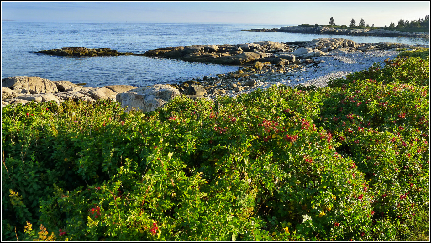
We relaxed and took our time on the long drive back. Along the way we stopped at Schoodic Peninsula, which is always gorgeous. It was sunnier and warmer here than it had been in Eastport. We sat on the rocks for a while watching some black ducks that we haven’t yet identified swim along by the thousands.
We continued the drive around past Blueberry Hill, where we stopped for a few photos in the slanting light. We got back just before 7:00pm, tired and still stuffed. We abandoned our plans for a pizza supper because we only had room for Puffys and wine!
