Breakfast was our traditional meal for dad’s last day: bagels (cheese and 3-seed) and sticky buns at the waterfront before a walk on the Shore Path. Another gorgeous morning! We tried to convince him to stay longer, but Dad was packed up and ready to head home by around 9:30.
George Dorr’s Mini Precipice?
After Dad left, Rich and I took a walk over to Spring Street to search for evidence of George Dorr’s “mini-Precipice” that was supposed to have been set in the ledges adjacent to Glen Mary Park. We found some great ledges that would have been perfect for such a path, but we couldn’t find any rungs or even a sign that there had been rungs on them, and we searched the entire area.
It’s hard to find any information about this mini-Precipice. J. R. Libby, a local blogger whose website helped us find the Great Cave, wrote the following:
George B. Dorr, in honor of the work crew that helped build the Precipice Trail, built a miniature version of the Precipice trail by Glen Mary Park in downtown Bar Harbor. It was on a cliff with ladders and iron rungs so people could go there and practice before attempting to hike the real thing.
Exploring the Bicycle Path
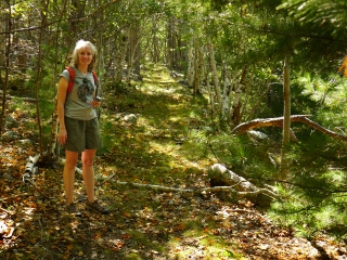
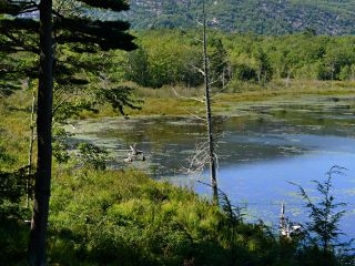
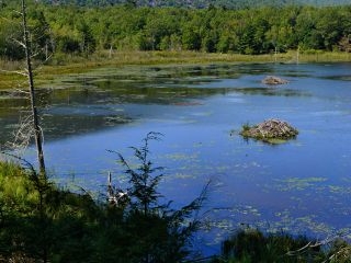
Our next stop was the Village Green, where we boarded the Island Explorer bus to Sieur de Monts yet again. This time we went further, though, and asked to be let off at the Champlain North Ridge trailhead. We weren’t of course hiking that trail; we were headed back to the Dorr Bicycle Path to explore as much of it as we could find.

We found it again easily and Rich improved the cairn he had established yesterday. Then we began to follow the trail, which was very easy to discern. Someone else else hikes this path too, as evidenced by the cairns placed here and there along the way. Just a few yards beyond where we ended yesterday, we found a boundary disk (USA/PVT) on a granite post. (And we found yet another one further on, at a point where the trail comes very close to the Bear Brook Pond.)
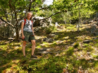
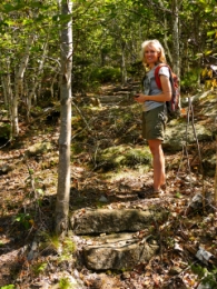
We also easily found the steps up to the Champlain North Ridge trail! The steps emerged on the North Ridge Trail at the spot we had suspected yesterday but hadn’t investigated in depth. The path to the steps is “disguised” by a thin but gnarly branch. It looks ridiculous as a barrier, but most people probably don’t even notice it.
I’m thinking that the steps were part of the original route of the Bear Brook/Black Path (now Champlain North Ridge Trail). Our GPS tracklog matches exactly with the former routing of the trail as shown on the USGS topo map and the old path maps.
According to Pathmakers (p. 219), “The lower, northern end of the trail was rerouted by the CCC during the motor road construction as part of the circulation system for the now-abandoned Bear Brook Campground.”
We were able to follow the remnants of the bicycle trail all the way out to the Loop Road. Rich noticed a nimble fawn, still adorned with a few of her spots, standing about 10 yards from us and not frightened at all. Just yards from the road, it felt like we were deep in the Acadian forest. We came upon a loop trail crossing through the woods, and another trail heading west. Was this perhaps part of the old Wild Gardens path established by George Dorr in 1916? According to Pathmakers, that trail also passed through the area near Beaverdam Pool.
When we emerged on the road, we took a waypoint at the “trailhead” for future reference and continued on the loop road, thus completing our own loop back to Sieur de Monts. But we weren’t done yet!
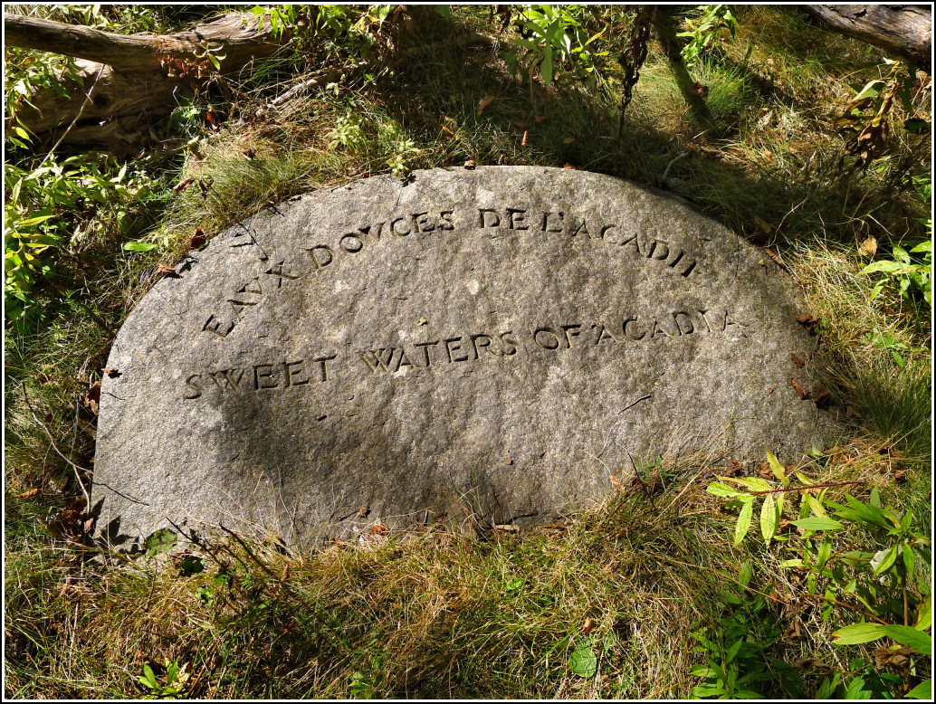
A very mysterious carved stone
Our final goal for the day was to locate the abandoned “Sweet Waters of Acadia” stone. Most visitors to Acadia have probably seen the boulder near the Sieur de Monts Spring House that’s carved with the words “SWEET WATERS OF ACADIA.” (Makes sense that it’s near the spring house, right?!) According to NPS’s List of Classified Structures in Acadia (no. 194) the stone was commissioned by George Dorr to be placed at the spring house. There is no mention in any official database or publication that I can find, of another Sweet Waters monument.
And yet that’s just what we found, half-buried beneath pine debris in open woods just off the Park Loop Road near Sieur de Monts. This semicircular stone contains two engravings: “SWEET WATERS OF ACADIA” in English and its translation, “EAUX DOUCES DE L’ACADIE,” above in French.
It’s a pretty stone, easily as nicely carved as the other memorial stones in the park, with no misspellings or obvious errors. So why was it not used? Or was it used, and then discarded at some point? If it was discarded, why here; why wasn’t it placed elsewhere or completely removed from the site? And why is there apparently no record of it anywhere?
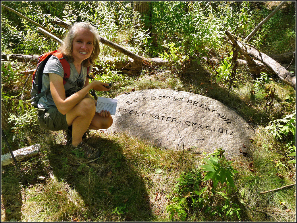
The only information we’ve found about this stone is in “Acadia National Park’s Discarded “Sweet Waters of Acadia” Slab” from The Memorials of Acadia National Park, a blog by Don Lenahan. (A photo of the stone does appear in Pathmakers but with no accompanying information.)
Lenahan gives a pretty thorough analysis of the stone and has likely found its original location: near the pool by the spring house, both of which were part of a larger bottling house operation. He quotes two Bar Harbor Times articles (1915 and 1916) that describe a flat stone with both English and French inscriptions at a reception room building (that is no longer standing) near the pool.
Lenahan still has the same questions we do, though. Why was it discarded, why here, and why is it still here? (We are also wondering how anyone came across it! It’s well off any beaten path, and not in a terribly pleasant place to walk.)
Our afternoon
Fantastic Fiddlers Green
Supper tonight was at Fiddlers Green in Southwest Harbor. We choose Fiddlers Green when we’re looking for a quiet, relaxed atmosphere, good food and great beer (so, really, we could probably eat there every night!). We sat on the covered porch, as we always do, and it was nice and quiet although the crowds started coming in as we were finishing. We started with IPAs and mushroom/cheese/spinach soup. Then Rich had the duck with roasted potatoes while I had the sole with rice. Both came with fresh green beans, carrots and onions in an herb butter sauce. Dessert? Of course! I had the Heidi cake, as always, and Rich got the special: lemon “moose” with blueberry topping.
We stopped at the Hannaford before settling in for the night, to pick up some wine and other provisions just in case Dave and family stopped by after their Haunted Bar Harbor tour. They didn’t and it was just as well since we were in bed early!

Interesting find, my guess is the Park Service doesn’t even know the existence of the stone. For many long years they “Lost” the Homans Trail, I was surprised when I read read that because during its lost years I was hiking it with my oldest son. You didn’t happen to have the GPS for this stone, do you? I had always thought the Dorr guest cottage had been torn down but discovered it still stands, beautiful old cottage being used today as housing by the Park Service.
Thanks, J.R.! I’ve discovered so many fascinating features of Acadia through your blog. I recall reading the story of the Homans Path in “Trails of History” and “A Walk in the Park,” both by Tom St. Germain. We’ve hiked it a few times and it’s so beautiful. At least the Park Service came to their senses and officially added it back into the trail system.
The coordinates we recorded at the site of the stone are:
N44.364111°, W68.204243°
So I have some good news, I went through my old newspaper articles and found one from Bar Harbor Times dated September 18, 1915 as the area around the spring was being build. The reporter takes you step by step through the property and what will be where when the project is completed. So the large stone with the words Sweet Waters of Acadia engraved on it was to be placed by the covered spring house, the second stone, with french words Eaux Douces de l’Acadie – which means Sweet Waters of acadia, was to be placed a short ways away, by a small pool of water with stepping stones leading down to it and ferns and other flowers planted around the pool of water. This pool of water with the stepping stones is there today, minus the stone you uncovered. Between the Nature building by the wild gardens and the spring house, a wooden foot bridge crosses the brook, facing the spring house, the pool of water with the stepping stones is to the left and that is where that rock belongs. I do not have the final paragraph of the news story, but I copied it as best as I could, print was a bit hard for me to read in some places. Story as follows; Bar Harbor Times
September 18, 1915
Sieur De Monts Spring Attractive
Three Buildings On Picturesque Site
WORK NEARS COMPLETION
Beautifully Laid Out Grounds Open To The Public – What Is To Be Seen There
A grand addition to the attractiveness of Bar Harbor will be made by the grounds and buildings of the Sieur de Monts Spring Company in a picturesque spot at the base of Dry Mountain, lying below mountain lands of the Public Reservations. These attractive little buildings – a spring cover house, and a reception room with a photographic exhibit of the surrounding landscape – are now well along in the course of construction. The grounds are carefully laid out and graded with a careful eye to preserving the remarkable purity of the water of the spring through careful drainage of all surface waters and to enhancing the natural beauty of the spot. All the lands owned by the Spring company, including the whole meadow through which the brook from the spring flows, with the woods upon it, are to be placed under the control of the Sieur de Monts Arboretum and Wild Gardens Corporation to assure the permanent preservation of its natural charm and freedom to the public. The water of the spring will be made free perpetually to all who come to it. The incorporators of the spring company are George B. Dorr, president; A. Stroud Rodick, treasurer; A.H. Lynam, clerk; E.G. Fabbri and Dr. Robert Abbe.
The entrance to the spring is from the Otter creek road, the drive continuing past the spring through a beautiful wood and coming out on the Harden Farm road east of Mt. Kebo spring.
As one approaches along the wooded entrance drive and sees the trees opening out and the beautiful spring cover house rising against the woods ahead, one is impressed with the wonderful layout of the grounds which will be extremely attractive when work on them is complete and they are swon with grass. By the side of the cover house is a big boulder bearing the inscription – “Sieur de Monts Spring.”
On the right of the drive, opposite, are the bottling house and the little reception room building. Between, is a deep, rock-enclosed pool about which will be planted ferns, irises and other native greenery. Close beside the pool will be set a tablet bearing an old french description of the regions drinking waters – Eaux Douces de l’Acadie, with its English translation below, Sweet waters Of Acadia – while stepping stones will lead out into the water of the pool that anyone passing by may drink of the waters as they boil freshly up.
An interesting hour may now be spent looking over these buildings and more closely examining the layout of the grounds. The reception room, which is first reached, is the old 16 foot square spring cover house used by John Prescott when he owned the property. It is to be fitted up with a table holding the spring book and various reading matter relating to the spring and to the island, and photographs of the island’s scenety exhibited upon the walls.
The bottling house just beyond – John Prescott’s also, but remodeled – is an interesting little structure in its present form. An arched doorway on the right, an arched niche for the overflow fountain on the left, with a gallery in the center above upon which an arched doorway and windows open, all combine to give it an attractive appearance with unbroken symmetry. Under the gallery will be a large map of Mount Desert Island in color on cement. The lower floor of the building is occupied by the bottling and other working rooms. Here an electric pump will draw some eight to ten gallons a minute from the spring, the water being singularly pure and cold – the temperature remaining at about 44 degrees the whole year round. All pipes are cement lined so that no metal comes in contact with the water. The pure water is only to be bottles. Occupying the front hall of the second floor is a rest room attractively burlapped in gray for the display of landscape photographs.
The spring cover house is to be octagonal in shape, 14 feet across, of cement with red tiled Florentine dome and is being built by Fred Savage, the architect, after a classical design made by Egisto Fabbri; older brother of Ernesto and Alergauidro Fabbri, and artist and architect whose house is in Florence, Italy.
Hi Zhanna. I’ve stumbled on your blogs as I have gotten into finding abandoned trails here in Acadia. I think I finally found where the stone that said ‘Sweet Waters of Acadia’ on it WAS. In the earth was an indent, same shape and size, but no stone. So I’ve looked around at Sieur De Mont Spring and couldn’t find it anywhere there either. Do you by chance know what happened to it or where it is today?
I’ve really enjoyed reading your adventures in Acadia. Right now I’m searching for the potholes trail blog, so I can find it some day. What year did you find that so I can find your description quicker? (although I am enjoying searching through it all-you’ve done and found so much)
Thanks so much!
Hello Kate, I’ve sent you some details via email. We found the Potholes in 2012 and have hiked it several times since. It’s a real shame if the Sweet Waters stone is gone, unless the Park Service intends to feature it somewhere in the park, which would be great.