Rich has mentioned Wyalusing Rocks many times and although it’s not far from home, I never managed to see it. Today we decided to go for a little ride out Route 6, check out the view from the Rocks, and then do some benchmark hunting in the area. It was a perfect laid-back plan for a warm mid-summer day!
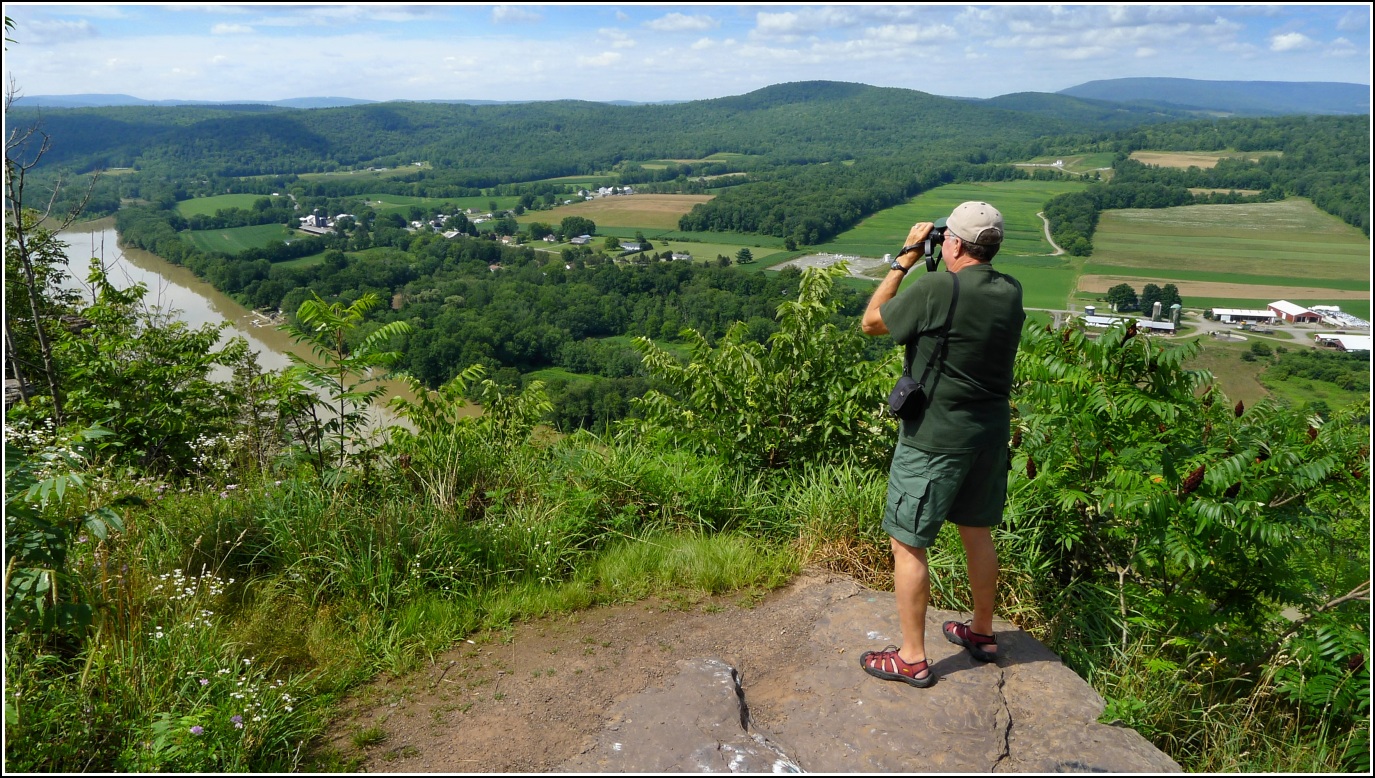
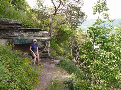
Wyalusing Rocks, also known as Prayer Rocks, towers about 500 feet above the Susquehanna River. The lookout offers not only a spectacular view but it also has an interesting history. The rocks are situated near the intersection of the Warrors’ Path, a Native American trail leading from New York to the Carolinas, and the Wyalusing Path, another Native American trail whose exact route is unknown. Currently the land containing the rocky outcrop is owned by the Eastern Delaware Nations, a group largely comprised of descendants of the original native tribes of this area. (The parking area is owned by the state of Pennsylvania and maintained, such as it is, by PennDOT.)
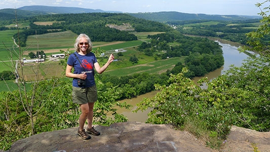
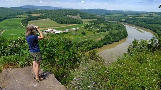
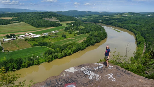
A short path leads out to the rocks from the parking area on the west side of Route 6. You can get a sense of the view from the parking area, but it’s most dramatic if you follow the trail out onto the overhanging rocks, where the ground just falls away beneath you and the river and fields stretch out before you, bordered by the mountains of the Tioga State Forest in the distance. A few footpaths wind in and out of the overhangs and ledges. The graffiti on the rocks detracts but only slightly; it’s annoying but easy enough to ignore when you’re focused on the view.
We hadn’t brought lunch with us today, but this would be an excellent spot for a picnic or a snack. After resting and exploring for a while, we began the second part of today’s adventures: searching for survey marks!
Our first benchmark-hunting target was a triangulation station near the Rocks called, appropriately, WYALUSING. We expected this to be an easy find (assuming it were still in place) because we had adjusted coordinates for the station, and all three marks should have been very close to the road. Little did we know we’d come across one of the strangest tri-station situations ever!
After our time at the Rocks we made our way along Homets Heights Road toward the coordinates for WYALUSING. The coordinates brought us right to the edge of a field lined with high grass and weeds. We checked carefully but saw nothing obvious. Our initial assumption was that the monument was buried.
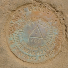
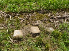
Our next step was to look for the reference marks. We found RM 1 just about where we expected to, based on the handheld coordinates from the datasheet. But what’s this next to RM 1?! Another concrete monument is just a few inches away. The disk on top is the station disk. The monument obviously was moved and then re-embedded in the ground. Bizarre!
And what’s even more bizarre is that it took us a minute to realize that there is a third monument (RM 2) right in line with RM 1 and the station! All three monuments are within inches of one another. The only one that might still be in its proper place is RM 1, although we can’t be sure. The distances given in the box score make it clear that the station and RM 2 have been moved.
There is a house on the property, but it didn’t look like anyone was home. We knocked on the door anyway, and after a minute a sleepy-looking elderly man appeared. He was friendly but didn’t know anything about the history of the marks, or when or why they might have been moved. He had noticed them, but assumed that they were all part of one piece of concrete. We moved on to the other marks on our list.
An auspicious “BM 680” on the topo map indicated that there is (or was) a bench mark on the wingwall of Wyalusing’s Rainbow Bridge, but we haven’t yet ordered the USGS datasheets for this quad, so we don’t have a description for this mark and had no idea what we would find at the coordinates. Aerial imagery indicates that the bridge is still a 4-span Parker through truss bridge, just as constructed in 1942, so it was a distinct possibility that the mark was still in place and undisturbed.
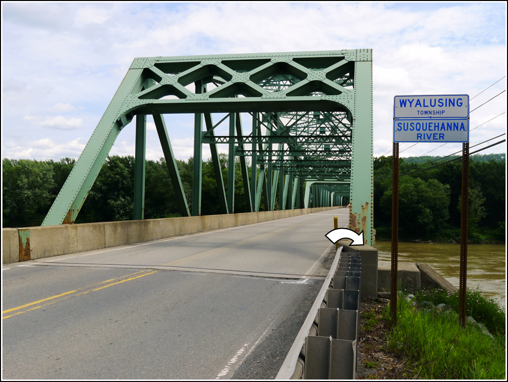
When we arrived at the coordinates, Rich let out a hoot-“Hey, look at this! Two disks!” There were indeed two disks set in close proximity at the southeastern wingwall. One was the USGS mark indicated on the topo map (62 HLZ), which is set into the bridge wall above the wingwall, and the other was DRM 070, a new (2013) PennDOT disk. It’s in good condition and is otherwise unremarkable, but how exciting it was to find two marks for the “price” of one!
The bench mark on the topo map is actually an old PDH disk, probably set anywhere between 1942, when the bridge was constructed, and 1968, when it was surveyed by USGS and stamped “USGS 62 HLZ 1968”. This is one of a few examples of old PDH/PDT marks being later repurposed and stamped by USGS. We also recognized HLZ as Harry L. Zehner, surveyor of two USGS marks we found last year near Cortez (1 HLZ and 3 HLZ). The disk is in very good condition and enjoys a scenic spot overlooking the river (or it would, if it had eyes).
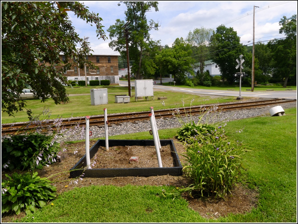
The next mark on our list was an NGS bench mark from 1934 near the old Lehigh Valley Railroad station in Laceyville. Despite the fact that this bench mark was reported found in 2005, it still felt like a long shot to me. I typically don’t have high hopes for marks near old railroad tracks, especially when they’re set in concrete posts, which easily and quickly become buried. But Rich and I were pleased to see that a small park now exists at this site, and we were absolutely thrilled when we noticed the mark as the centerpiece of a small landscaped bed. It has the appearance of an enthroned queen! The disk is in excellent condition, and the post still projects about six inches and has received a coat of red paint sometime in the past few years. “Wow,” Rich kept saying, “I can’t get over that!”
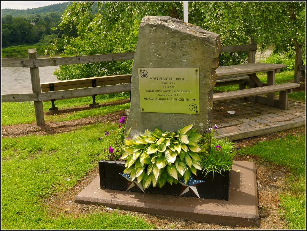
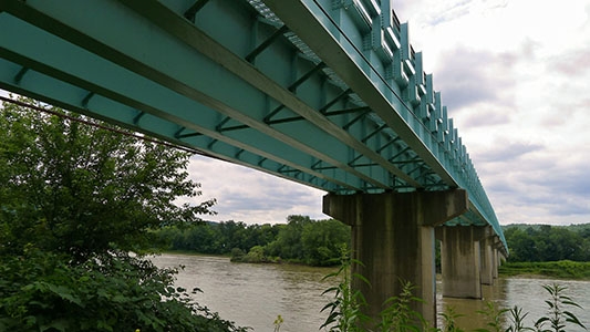
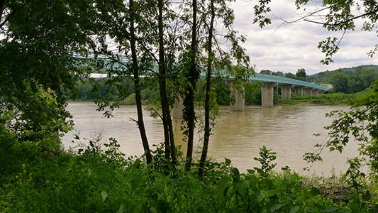
Laceyville’s Church Street Bridge received the American Institute of Steel Construction’s “most beautiful bridge” award in 1975. That sounds like an impressive accomplishment for a bridge in such a small, relatively remote village, but the structure really is stunning. The turquoise-painted open-grate bridge is obviously well maintained, and it has a gracefully curving deck.
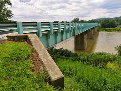
While I investigated the kayak launch site on the riverbank just west of the bridge, Rich stayed near the bridge to take some photos. When I returned, he pointed out another mark to me. It’s an old PDT mark that has recently been stamped with a modern PennDOT designation. The disk is in good condition.
We rounded out the day with a scouting mission to a USGS bench mark, 45 EWS, north of Skinners Eddy. According to the description, the mark was set into a large flat boulder just west of the highway. We had seen a few reasonable candidates for the large boulder on Google Street View, but when we drove slowly by we couldn’t spot a mark on any of them. We stopped and considered approaching the house to ask the property owner, but were intimidated by the loud barking of a dog. Eventually the owner emerged and while she was willing to help and offered to let us search, she said that the yard had recently been landscaped and the boulders had been moved. She had also never spotted a disk on any of them. We got out and searched all the visible boulders in the area anyway, but found nothing.
