Today’s post title follows the same pattern as last week’s (R.I.B(M).S.)—a bit less inspired, perhaps, but just as delicious! And before the burgers, you can see, come the benchmarks!
We returned to the Waymart area today to complete the three searches that remained from last weekend’s loop of eight marks. The first mark on our list was in Pleasant Mount, and our GPS routed us north through Clifford rather than through Waymart as we had expected. Along the way, I noticed this old concrete bridge with a PDH plaque.
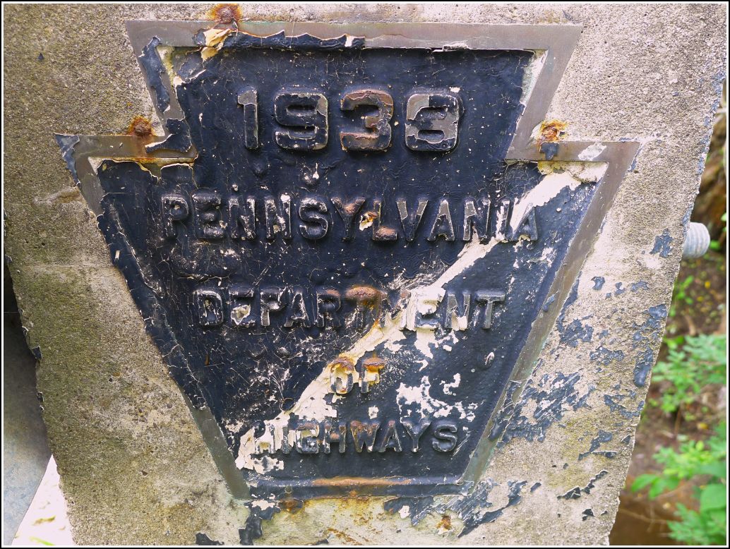
Rich pulled over, and Dad and I checked the wingwalls for benchmark disks. We didn’t see anything obvious at first, but then I noticed the designation 96-35-1013-2 written on a metal plate fastened just above the southeastern wingwall. The wingwall was encrusted with mud and gravel, but we scraped it off and found a nice PDH survey disk hiding underneath. It’s an old disk, but it was stamped (we assume in 1996) with the modern PennDOT designation.
Just a quarter mile north along the same road we found another PennDOT mark. (It’s a good thing we happened to notice these marks, because they were the only ones we found all day.) There is absolutely nothing remarkable about this mark—it is a new-style PennDOT survey control disk set into the eastern barrier of a bridge over a branch of Dundaff Creek.
The first USGS mark on our list was TT 31 A. I was excited by the prospect of another old TT mark in the area, but I’m afraid this one is gone. The former orchard—still undisturbed in the Google Street View image from 2008—is now the site of a large garage, and the entire area around the coordinates has been modified. Boulders have been plowed up against the bank of fill on which the garage sits, and heavy equipment has cut tracks through the mud.
Dad and I found a large rock (heaved up out of the ground) at the site of the coordinates we had pulled from the topo map, but we could find no sign of the disk on the rock. The rock did appear to be an excellent setting for a mark, and it’s possible that the disk was on the underside of the rock. In any case, I’m quite sure the mark is no longer viable. We thought maybe someone at the garage would have an idea how the land had looked before the excavating and filling, but the garage was deserted on this Saturday morning, so we had no one to ask. We moved on to 38 M.
We’re nearly sure that 38 M is still in place, and Dad and I think we saw the boulder that it’s set into, but a twenty foot wide “moat” of thick poison ivy prevented us from reaching it. Beyond the Evil Weed, the woods are open and easily hikeable, and the boulder is only a few dozen yards into the woods anyway. But we weren’t about to risk a reaction, which I would surely get. Dad is still pretty sure that he’s among the very small percentage of people who are immune, or at least resistant, to poison ivy, but he doesn’t want to find out the hard way. I would love to try this one again, though, perhaps when there’s a layer of snow on the ground, or with some protective measures.
The final mark on our list was 37 M. Ugh … 37 M.
It began like any typical search. Our route toward the coordinates followed a dirt/gravel road. I spotted a protruding ledge in the woods, just off the road, that seemed to be a very likely setting for the benchmark. The area was not posted and there were no residences or other buildings, or any signs of life around to approach for permission. Ordinarily I would’ve just walked to the ledge and looked, but in this case, thick poison ivy stopped me. We could see the noxious weed from the car, and we decided to skip the search, just as we’d done for 38 M nearby.
As we were gathering our datasheets and getting the GPS ready for our next destination (burgers!), around the corner came a guy in a pickup truck. He crawled to a stop and opened his window, and Rich opened his. The man gave us an arrogant sneer. I had a feeling what was coming.
Really, the less said about this encounter, the better. The guy completely flew off the handle even though we had done nothing wrong (we were sitting in a car on a road that he even admitted he doesn’t own). We hadn’t left the vehicle. We hadn’t touched any of his property. He was calling Rich and my father horrible things, with no real provocation or justification. Obviously, we left and won’t be returning to this area. It’s a shame that this guy, if he truly owns the land, hosts an historical treasure that most other people would be honored to know about.
So I guess in this case I have poison ivy to thank for keeping me out of the woods, where I might otherwise have been when this crackpot rounded the corner. I would’ve been caught red-handed, and things could have turned out worse.
Notes to the guy, in case he ever reads this:
- You don’t own the road.
- Seriously, dude, post your land if you care that much. Otherwise, it’s obvious you’re just looking for trouble.
- Don’t piss off my dad. He apparently goes from 0 to 60 in 2.3 seconds!
Regardless, we didn’t let this guy ruin our day. And b(m)urgers and beer soothe almost all frustrations!
