Today Rich and I set out on a benchmark hunting trip in the Waymart area. We are on a quest to find more “J” bench marks, those set in the mid-1920s by Oscar Jones and which, so far, have all been made of Aich’s metal.
The first mark on our list was TT 9 J, near the old Erie railroad station at Hoadleys. The Erie & Wyoming Valley station and tracks are long gone, but part of the old railroad bed remains (and part has been turned into Railroad Drive).
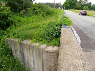
We entered the Cherry Hill Mobile Home Court, passing by the yard sale set up at the entrance, and drove east toward Middle Creek. At the point where Railroad Drive meets Mangs Road very close to (but beneath) the Route 191 bridge, both roads end, but the old railroad bed continues south to pass under the bridge. We walked down the railroad bed, which was open and grassy at first but quickly became overgrown and swampy underneath the bridge. This is the general area in which we would expect to find the boulder, but we could see nothing. It’s possible that if the boulder is still in place, it was covered by vegetation at the time of our visit.
Investigating further at home, we found on an 1892 topo map what is probably the old Erie & Wyoming Valley station, but the map scale isn’t sufficiently detailed to tell us just where the station was. It may have been slightly north of where we were searching. We discovered something else interesting a day later when we looked at the historical aerial images at PennPilot: the original highway alignment (Route 90) actually followed what is now Mangs Road. When the highway was reconfigured and the current bridge was built, it’s possible that the area was excavated and the boulder was moved or buried.
We were on our way to the next mark on our list, TT 8 J, along Tannery Road. We were interested to see if Middle Creek Road truly does connect all the way through to Tannery Road; our Garmin nüvi was showing that it does and routing us that way, while Google Maps shows a gap of approximately ¾ mile. (It turns out Google Maps is wrong. Middle Creek Road does connect through to Mill Brook Road and then Tannery Road.)
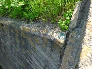
Rich suggested that I check the bridges along the way, and I was thrilled to find 48 DSW on the northeast wingwall of this bridge! I was not thrilled, however, at the copious amount of poison ivy thickly surrounding the bridge on both sides. On the next bridge along this road, we found yet another mark—an unstamped PennDOT disk.
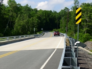
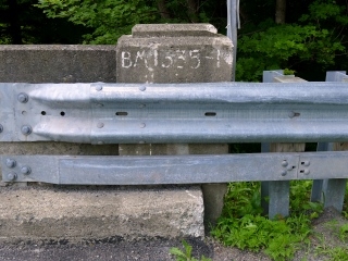
Further on, we found yet another PennDOT disk, 10-63-2034-4. This was unexpected find #3 for today, and a very strange one because there is a USGS disk (47 DSW) on the same bridge. Both are located on the south side of the bridge; this PennDOT disk is on the southeast wingwall and 47 DSW is on the southwest wingwall. Our only guess for the reason was that 47 DSW is now only half-exposed (and difficult, if not impossible, to use as a control point) because at some point a new bridge deck was constructed on top of it.
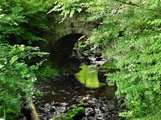
The real find here was the moss covered stone arch bridge half hidden in the woods just south of the highway bridge. It would fit in perfectly along Acadia’s carriage roads, but this was no Rockefeller bridge. We guessed—correctly, we later learned—that it was part of the Pennsylvania Coal Company’s gravity railroad running between Hawley and Pittston (not to be confused with the D&H Gravity Railroad that ran through Waymart).
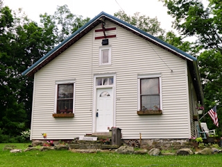
We then drove west along Middle Creek Road (which becomes Tannery Road at some point) toward Clemo, serendipitously finding some benchmarks along the way, and ending up at the old schoolhouse. Awesome! It’s still here, still looks like an old schoolhouse, and even has a little wooden “SCHOOL” sign in front (obviously not period-authentic, but still a really cute touch honoring the building’s past).
We were disappointed to find that no one was home. We would have loved to learn more about the old building and tell the residents what we know about the bench mark disk. I’m certain they know about it; we found the bright gold disk easily on a small outcrop in the yard just a few yards west of the old schoolhouse. It is in fair condition, with many surface gouges probably resulting from its exposed location, but the disk is very solid in its setting and the designation can still be read with some effort. We later discovered the name of this school—Box School—on July 26 while at the Wayne County Historical Society in Honesdale, in the book Rural Schools of Wayne County by Mimi Steffen.
We continued on. 03-63-3018-6 was an unplanned find on our way to search for TT 12 T near St. Tikhon’s monastery. Near the monastery, we knocked on the door of one of the houses near the coordinates. A frazzled-looking woman answered; fortunately she was friendlier than she looked. She spoke with a strong New York accent, which led me to think she hadn’t lived here very long. She didn’t know anything about the Hetzel family mentioned in the description. She also knew nothing about the mark.
The large building at the driveway entrance (perhaps the old farmhouse?) apparently belongs to the monastery. The woman was reluctant to allow us to search because, according to her, most of the grounds, even on this side of the road, belong to the monastery as well. She advised us to try to contact the monks for permission. (If our experience at GREEN is any indication of how well monks and nuns take to survey mark hunting on their property, I’m going to say that it won’t be worth the trouble.)
There is a small slope covered by vegetation in the approximate location of the coordinates. We looked at this area from the driveway, but we couldn’t see anything obvious. We may have to attempt to get permission, or at least take a closer look in a less weedy season.
52 DSW was a fitting end to an exciting day of benchmark hunting! 52 DSW was among the original four marks we had planned on searching for today. The description is accurate and it took us right to the correct spot, and I found the mark easily. There was no good way to climb down to the level of the wingwall, so I photographed the disk from above while drivers flew by, eyeing me up, as Rich described it later, even as they sped past. I had assumed that by wearing my safety green “SURVEY STATION RECOVERY” shirt most people would assume I was just working and would ignore me but no, they seemed as curious/nosy as ever.
After all that, of course we wanted a nice easy supper! We went to the Waymart Hotel for pizza and BBQ, afterward taking a walk through their rock garden, which needs some cactus! After our meal, we spent some time in the Gravity Railroad Museum talking with Jane Varcoe. It was Waymart’s “reunion weekend,” she said. We learned about how to get up to Shepherd’s Crook (behind Whites Crossing fire station—either take the long gradual climb, or the steeper climb from Simpson). Jane claims there is a benchmark somewhere near Farview. Is this the one by the windmills or … ?! And how do we get there? What is the brick building/house referred to? We may need to go back and ask her.
