A few weeks ago, while we were hiking along old Route 611 (now a trail in Gouldsboro State Park) toward the coordinates for WANNA AZ MK, Rich was reminiscing about his family’s drives to New York on old Route 611. “I remember there was this neat old roadside place that had a windmill. It was somewhere south of Daleville. We never stopped there, but I think they sold hot dogs, or ice cream. I just remember seeing the windmill.” I literally stopped in my tracks. “Really?! I just read a benchmark description where I swear they mentioned that place!”
For the rest of that day, and for the next week or so until I finally found the benchmark description again, this drove me nuts. It had probably been about a week before Rich mentioned the place with the windmill, and I had been reading USGS datasheets, so I assumed that’s where I had seen the mention of the windmill. I went through each possible quad several times until I was convinced the description was not among them. Finally it occurred to me that maybe it had been an NGS mark instead, and it was. From the description for X 281: “… ABOUT 150 FEET NORTH EAST AND ACROSS THE HIGHWAY FROM A HOUSE (THAT USE TO BE A BUSINESS) WHICH WAS BUILT TO LOOK LIKE AN OLD DUTCH WINDMILL …”.
Meanwhile, we were asking everyone we could think of if they too remembered the old place with the windmill, and could recall the name or pinpoint the location. Almost no one remembered it at all, and no one could come up with the name. But once I found the correct datasheet, it seemed clear that we would be able to identify the building (if it still existed, although the windmill is obviously long gone) or at least the spot where it had stood. We began at home, with our usual investigations on topo maps and Google Street View. We couldn’t see any obvious boulder that looked as described, but we saw a rock of some kind and near it, a wooden stake with flagging tape. It appeared promising. Today was the day to investigate in person.
While on our way to Daleville today, Rich and I took another shot at TT 2 J, a USGS bench mark that should have been located at St. Catherine’s Cemetery south of Moscow. We looked for this mark briefly a few weeks ago with Dad. The three of us spread out and searched the entire hillside near the road, from one end to the other, without any luck. We found plenty of small outcrops that could have been good settings for a mark, but there was no mark to be found. Without knowing where the church had once stood, we didn’t have much information to go on.
Today we brought our documentation to the caretaker’s building. We were fortunate to find there the groundskeeper, who had worked at the cemetery for many years! We thought for sure he would know of the disk if it was obvious. He didn’t, but he was very talkative and most willing to give us any information that could be helpful. Our first point of confusion concerned the location of the former church. Where, exactly, was it?
The groundskeeper hadn’t been around that long, but he pulled a framed photograph off the wall and said “I have an idea where it is, and this should help us figure it out!” I just love this kind of thing. We were able to use the two prominent grave monuments shown in the photo (which, of course, still exist) to determine where the church had been and how it was oriented.
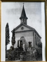
The current St. Catherine’s Church is located on Church Street in the center of Moscow. That church was built in 1923. The first church was in the cemetery, and it is this church that the mark was near. It’s not clear when the first church was built or when (or how) it was destroyed. We couldn’t find anything and we suspect that the monument was removed or, more likely, just covered over. Rich and I moved on along the highway toward Daleville and, we hoped, X 281.
We drove the prescribed distance south from the intersection of Routes 307 and 435 and arrived at a place called Knecht’s Country Store. We were as eager to solve the mystery of the windmill building as we were to find the bench mark, so first we looked for any signs of life around the store. Despite a sign that read “In back potting plants, please beep horn or call [phone number]” there was no one anywhere on the grounds. We peered through the window of the small store and saw nothing but some old junk and a huge stuffed black bear (which Rich wanted to bring home for our porch). Rich said it was possible that the windmill had been in this area, but it still didn’t look quite right to him.
Before looking around for anyone else to ask, we crossed the highway and searched for the mark. The stake with flagging tape was still in place, but the nearby rocks were bare and no mark was evident anywhere nearby. For the mark to have been set vertically, the boulder must have had a significantly large western face, and nothing in the area matched this description. Our best guess is that the boulder was removed when the road/shoulder was widened.
At the next house up the road, we watched a man pull out in a pickup truck just as we approached. Damn! We thought we had missed our chance to find out more about the windmill from the neighbors. No one else was at home but creepy mannequins placed all over the property—it was truly one of the most bizarre (and disturbing) things I’ve seen, and we should have taken a photo.
Anyway, we moved on to the next building, which although it was closer to the intersection than described, seemed to Rich to best match his memories. We went inside and the “country fellow” who came to greet us was happy to tell us that he knew all about the windmill—it had been his grandfather’s business! At the time the name had been Knecht’s Nursery. Now it belongs to his father and the name is, you guessed it, Knecht’s Country Store. The windmill was removed years ago. So it wasn’t a roadside food stand, and we didn’t ever find the bench mark, but Rich’s memory had provided us with a great adventure and a chance to explore and learn more about the Daleville area.
We realized ahead of time that the first two marks we intended to search for today were long shots, so we chose Z 281 as a confidence booster. The description is quite definitive, so we knew the mark would be easy to find—or at the very least, easy to determine if it was gone. We drove just about 1.2 miles further southeast along Route 435 form Knecht’s Country Store and easily found the concrete bridge over Tamarack Creek. Rich parked on the west shoulder of the highway while I crossed and found the mark on the southeast end of the south abutment.
