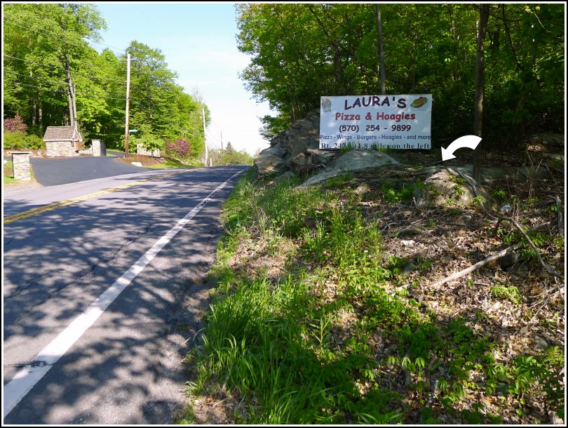
It’s always exciting when I’m idly reading through datasheets and discover a “new” mark—particularly when it’s close to home, and when we pass by it all the time, unaware! Stations that serve as horizontal control tend to surprise us more often because, other than the ET (electronic traverse) marks, most of them do not appear on topo maps. Last night I happened to read the description for this mark and was just about shocked to see that there is a mark along Route 247 (“the Wildcat”), which we travel at least a few times per week. A glance at Google Street View showed us that the mark should be set on one of the rock outcrops directly in front of the billboard for Laura’s Pizza & Hoagies, although we couldn’t actually see the mark in the Street View frames.
This Memorial Day morning, on our way to search for a few other bench mark disks in the Daleville and Gouldsboro areas, Rich and I stopped to search for this one. We found it quickly, set into one of the suspected rock outcrops. In a way, I still can’t believe that we hadn’t at some point noticed it when driving by, but it is well above eye level. Now that we know where to look, of course, this bright blue disk will stand out to us every time we pass by.
We headed out toward Daleville. When we were researching 35 JPN at home, it looked like it would be a simple find. We could see a nice flat outcrop on the Street View. When we arrived at the site, we had the same impression. In fact, the outcrop was even larger (and flatter) than we had expected, and it looked like absolutely the perfect spot for a bench mark disk. All of the references in the description matched up. But no disk was to be found!
I checked the outcrop as thoroughly as possible (part of it is covered with dried-out moss, which was difficult to remove, but I checked under it as well as I could). I also noticed that the outcrop has one section that may have been broken off at some point (a long time ago), so it’s possible the mark was on that section, but not likely because it was close to one edge of the outcrop. It’s certainly possible that we didn’t even find the correct outcrop, but we could see nothing else in the area that looked like a possibility. So for now, this one remains a mystery.
Next on the list after our strikeout at 35 JPN was 36 JPN. This was a relatively easy find in a wooded lot directly east of the t-intersection of PA Route 435 and Covington Lake Drive.
A quick reading of the description can be confusing. State Highways 611 and 307, a formerly multiplexed route, is now simply PA Route 435. Another potentially confusing aspect is that the “rd. E.” no longer exists. A powerline passes through a nearby opening to the south that may have once been a road or track road, but at about 160 feet south, it is further away from the mark than 75 feet, so we’re not sure if this was the road referenced in the description.
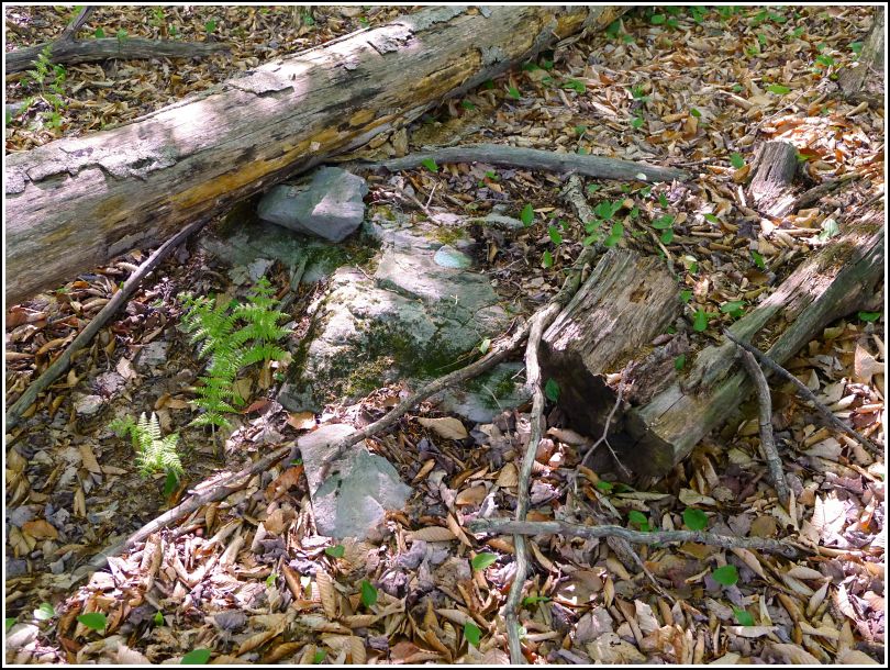
The disk is in good condition, although it was half-buried under soil and leaf litter when I found it and will probably become covered again in a short time.
I was very excited to search for TT 1 J, which the coordinates place very close to 36 JPN. I was looking forward to finding this one because all of the TT [x] J series we’ve found so far have been disks made of Aich’s metal, a beautiful sparkling gold-colored alloy that resists tarnish. We spotted a few likely outcrops on Google Street View, but when we arrived on the site, I wasn’t able to find the disk on any of those outcrops or anywhere else nearby. There isn’t much to go on (the coordinates from the USGS datasheets are sketchy, often quite far off—in this case, they put the mark on the wrong side of the highway) and the utility poles now sport new numbers, so I’m not even certain we were looking in the correct spot. Perhaps a late fall or winter day when the vegetation is down would allow for a more thorough search of the area. At that time we also might want to expand the search a distance up and down the highway. Also note that the highway in question is not, nor was it ever (according to PAHighways.com) State Highway 168 as it is referred to in the description. It is now State Route 435 and at the time this mark was set (1926) it was designated US Highway 611.
Moving on … Triangulation stations in easy-to-access locations like state parks are typically low-stress and lots of fun to recover. For some reason, we hadn’t realized until last week that WANNA was located inside Gouldsboro State Park, but once we discovered this fact, we made it our main goal for the day.
Our first attempt today to access WANNA was foiled by a particularly nasty swamp along the Old Route 611 trail. We came to within a few hundred feet of our targeted location for the reset azimuth mark, but the depth of the mud made us rethink our plan. We retraced our path along Old 611 and the old park entrance road back to the car, and drove out to Route 507 to approach the station from the northwest instead.
From this direction, it was an easy hike of about 0.2 mile along Old 611. The adjusted coordinates and a witness post (without sign) brought us directly to the location, but the marker and monument weren’t visible. We used the given distance and direction from the witness post to determine where to dig. After a few minutes, we had the disk and monument uncovered from under an inch of soil and leaves. Both the disk and monument are in excellent condition, probably due to having been buried for years.
The reference marks were even easier. We spotted both boulders from the station and made the finds quickly. The RM disks are also in very good condition, and because they are so close, there is a clear line of sight between both RMs and the station.
The azimuth mark—well, that’s a completely different story. Data exists for two azimuth marks for this station: the original, set in 1960, and the reset, from 1966. This is nothing unusual. What is somewhat unusual is that there is no definite statement that the original azimuth mark was destroyed, just that it was likely to be. So might it still exist? We wondered about this, and thought it would be worth looking for after finding the reset azimuth mark, which we didn’t expect to be too much of a challenge.
We hiked a bit further southeast along Old 611, keeping in mind that the reset azimuth mark is supposed to be about 0.55 miles from where 611 intersected Route 507 (the beginning of the current Old 611 trail). At approximately the correct distance, we found a track road (now a trail) leading north-northeast and, about 150 feet in, we found a large boulder matching the description. We were so sure the reset azimuth mark would be on this boulder but, to our extreme surprise, it wasn’t. Nor were there any other boulders anywhere nearby! Everything seems to point to this having been the correct location, but the disk simply isn’t there. Rich even joked that maybe the mark is still in the back of someone’s truck and was never actually set. It is interesting that there is no data in the box score for the reset azimuth mark. We’re planning to investigate further and perhaps return to the site if we have another insight.
Also of interest: we wondered why the original azimuth mark is supposedly so far away: 9.6 miles along Route 611 from its intersection with Route 507. Rich’s guess is that we found a typo and 9.6 miles was intended to be 0.6 miles, which obviously puts it in the same general area as the reset azimuth mark. This dimension, taken along with the angle from the station, puts the original azimuth mark in the median of I-380, which probably means that it’s long gone, or under so much fill that it’s not recoverable.
It was truly an awesome day filled with some finds, some misses, and sightings of a cub and momma bear, three or four scarlet tanagers, an osprey, and a small snake.
