It was still dark when we left the Ragged Edge around 6:15 this morning. Our goal was to reach the Key Deer Refuge on Big Pine Key early in the day, while we might still have a chance at seeing some key deer roaming around for their breakfast.
Our breakfast was a haphazard mélange: leftover Key lime pie from Tuesday night’s dessert, and key lime biscotti and mini sticky buns from Bob’s Bunz, which we ate on the way. We made it to the refuge by 7:30, encountering a few brief showers (the only rain of our trip) along the way. The raindrops weren’t even enough to dampen the ground, but they did generate a rainbow that we spotted as we crossed the Seven Mile Bridge!
A morning at the Key Deer Refuge
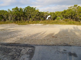
As soon as we arrived at the preserve, we drove all the way to the end of Bryant Road, the main access road into the preserve. Based on our topo maps and satellite imagery, we we expected to find a hiking trail leading northwesterly from the point where the paved road ended. And as expected, there was a sign and a sandy path heading off into the mangroves. There wasn’t any mention of an actual hiking trail, but from the road it sure appeared that we’d be a clear path leading off into the mangroves.
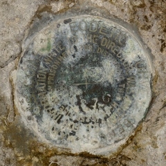
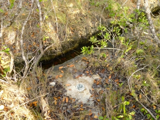
As usual, we decided to turn our attention first to the benchmark which appeared to be an easy target. The first mark was supposed to be in/near a “mosquito drainage ditch” which in its current overgrown state is even less impressive than it sounds. But actually, it’s quite cool how these channels were carved into the rock. This network of ditches drains the mosquito habitat in an attempt to control the population by providing channels to freely introduce fish, which feed on the insect larvae, to the area. We had quite a time getting to this mark in the overgrowth, and maneuvering in order to take a decent photo was also challenging. It took a few tries going back out to the road and looking for a likely spot before we zeroed in on the mark.
Our next goal in the preserve was to hike the trail that begins at the end of the road toward P 328, another benchmark in the 328 series. We expected only about a half-mile hike from the trailhead, if the benchmark’s scaled coordinates were at all accurate. But we didn’t get far! Whether it was from the early morning’s rain or it’s just a perpetually wet area we weren’t sure, but we could only go a hundred feet before the entire area was covered with several inches of water. Needless to say, we’ll leave this mark for another trip. It will definitely be worth checking on the conditions in the future!
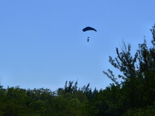
I seem to have developed a talent for spotting witness posts from moving vehicles. We spotted an orange fiberglass post on our drive into the refuge. Orange posts usually mean survey markers are nearby (especially when they’re labeled “Do not disturb nearby survey marker”) but we were unable to find anything near the witness post. I did, however, spot the rear end of a Key deer as he crashed through the brush, obviously disturbed by our poking around in the woods. I was thrilled to see that much of the deer. Needless to say, it was the only one in evidence that morning. We weren’t disappointed: the unpredictability is what makes wildlife watching so much fun!
The Key Deer Refuge features two short nature trails, the Jack Watson and Fred Manillo trails, which can be accessed from the same parking area. Conservationist Jack Watson was hired in the early 1950s to protect the remaining Key deer from poachers and attempt to restore a successful population. He became the first manager of the refuge in 1954.
His namesake trail is the longer of the two trails in this area (about 2/3 mile), and we hiked it first. It winds through an area of pine rockland and freshwater wetland. Signs of a recent fire were everywhere on this trail, and the burned pine trunks left the trail more barren and exposed to the harsh sun than I had expected.
I was hoping to spot some bromeliads along this trail, but I didn’t notice any, nor did we see any wildlife. But the trail passes through an area of almost alien curiosity, with its juxtaposition of tall, skinny pines teetering overhead, burned deadfall off to the sides of the trail, and palm leaves slicing at our legs and ankles as we walked by.
The Manillo Trail is interesting because it is entirely ADA-accessible, with wide paths where possible and frequent pull-offs. The surface is mostly emulsified gravel for easy walking and wheelchair accessibility, while still blending nicely into the natural environment (kudos to the trail builders for providing an accessible pathway that’s not an ugly strip of asphalt!).
The short length of this trail allows you to focus less on the “destination” and more on the unique surrounding habitat. We didn’t see any critters, but as a plant person I was thrilled with the variety of palms and palmettos, and trees growing in solution holes.
Poisonwood abounds here too, so be careful what you touch (or what you look at, for those of us who are super-sensitive to poisonous plants!). Many of these plants originated in the Caribbean, growing from seeds carried on the prevailing winds and dropped by migrating birds. The trail ends at a viewing platform over a wetland. It’s worth spending some time here, just like the nearby Blue Hole, which we visited next.
Rich had been thinking that Blue Hole was a hiking trail, but actually it’s a just a short jaunt from a parking area to a large water-filled quarry—a remnant of the construction of Flagler’s railroad to Key West! Another very short trail to the left leads to a second observation area. We saw turtles, ducks, and a catfish—no alligators, although we heard from other visitors that one had just recently been seen in the area.
While still in the refuge, we wanted to check out the visitors center. Good luck finding it! We drove all around a nearby strip mall before finally spotting the small (temporary?) establishment. They had a few Key deer-related items and several books about the Florida East Coast Railway that we’ll purchase when we get home. (No room to carry everything home on the plane!)
Sugarloaf Key’s Bat Tower
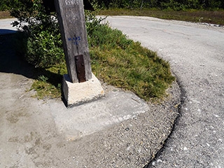
Our next stop was the famous Bat Tower on Sugarloaf Key, which we initially learned about a few weeks ago when searching for information about the Central Park Bolt, oddly enough. We came upon a slideshow about “The 25 Best Nerd Road Trips“; one of the slides showed the bolt. As nerds who like finding weird things on trips, we paged through the rest of the photos and saw the Bat Tower. With our Florida trip soon to come, the Bat Tower went on our list of must-see oddities. And as a major bonus, there is a benchmark set into the base of the tower!
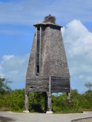
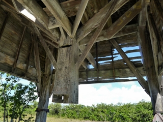
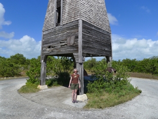
The tower is immense and definitely odd. It was built in an attempt to house bats that would in turn control the local mosquito population. One of the most interesting features is a central guano-removal chute! Unfortunately, the bats never took up residence. An inscription at the base of the bat tower reads
Dedicated to good health at Perky, Fla., by Mr. and Mrs. R.C. Perky, March 15, 1929.
(The benchmark’s designation is PERKY, quite a nice tribute.)
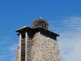
While the bats didn’t find a home at the tower, a family of ospreys certainly did. Perched atop the tower is a huge osprey nest. As we watched, two adults circled around (probably watching us intently) and one occasionally swooped into the nest to feed the young bird within. (He posed nicely for a few photos.)
The ospreys weren’t the only wildlife we saw here. On the road to the tower, we spotted a large, bright green lizard that we suspect is one of the area’s invasive green iguanas. He was really neat but you’ll have to take our word for it, because he didn’t hang around long enough for a photo.
We were very hungry by this point, and we had heard about a place on Stock Island called Hogfish that was supposedly a hangout for the locals as well as a great spot for local fish. Hogfish has a reputation for being hard to find, but we had no trouble thanks to GPS. Some may find the surrounding industrial “neighborhood” a bit intimidating, but we didn’t think it was really any sketchier than many of the back streets in NEPA cities.
Our first taste of Key West
The open-air restaurant is crazy and loud even at lunchtime … I can’t imagine what it would be like later. But it’s Key West (or very nearly so) and we were prepared for a little craziness! We loved everything we ordered. We started with Fat Tire Ales, conch chowder and coconut shrimp, and then we had the famous grilled hogfish sandwich with Swiss cheese, mushrooms, and fried onions on Cuban bread. It’s hard for a northerner to imagine how an open restaurant like this can be practical—but I can certainly appreciate it! The combination of liveliness and relaxation we experienced there would only be enhanced as we moved on down the road to Key West.
We checked in at our motel, Ibis Bay Beach Resort, on the outskirts of the city. Despite the name, it is not a “resort” by any means. Think of it as a motel and it’s basically fine. Our first impression was that it was a strange place, although we couldn’t put our finger on why. (I still don’t think we know!) But the room, decorated in bright colors in the Keys tradition, seemed clean enough, and the price was “reasonable” (for Key West).
Feeling beat after our morning adventures, we rested for a little while (attempting a nap while the hogfish swam in our stomachs!). Then we decided to take a drive downtown. We found a parking spot rather more easily than I had expected, along Eaton Street, and wandered for a while among the beautiful people, lush vegetation, and historic architecture of Key West.
Enough time had passed that we were feeling hungry again, and we spotted an information booth where we stopped for a few maps and to ask where we could find some good Cuban food. “El Meson de Pepe,” they recommended. We had the impression that it was a touristy place, but hey, we’re tourists right now, and we were hungry, and it was right near Mallory Square. Definitely worth checking out the menu, at least.
Touristy or not, we knew we were in for a treat when we spotted the tables scattered around in various outdoor settings and the Cuban musicians playing nearby. The place was lively but still quiet enough on the porch for us to enjoy some conversation about our day. Our server, Jason, explained some of the menu items and had some excellent recommendations for us. We started with an assortment of Cuban breads and crackers served with two dipping sauces, a peppery red and a tart green, that were some of the best sauces of any kind I’ve ever had. Although we wanted to save room for our entrees to come, we had to finish the bread because it was just that good.
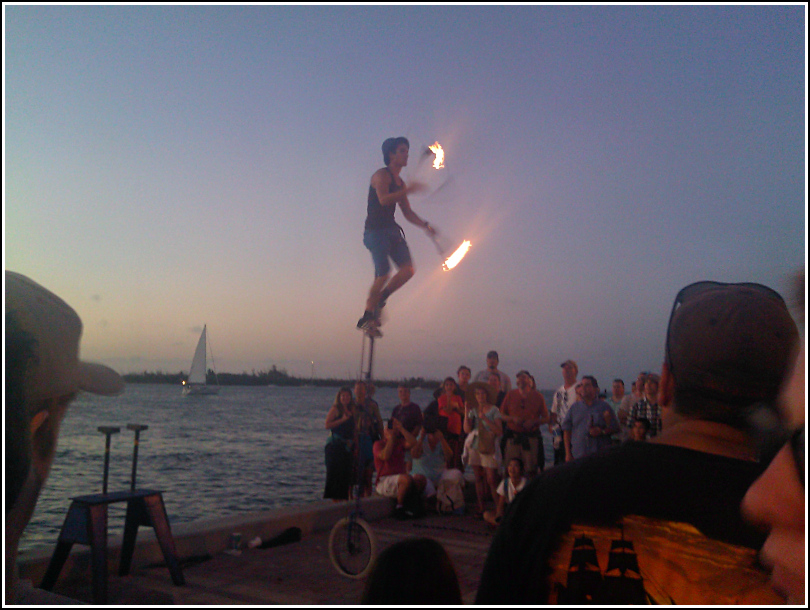
Our entrees were cubed pork and onions with more of the green mojo sauce, and shrimp in Cuban creole sauce. They were served with saffron rice, black beans, and awesome fried sweet plantains that we could have eaten about a hundred of. There was no room left for dessert, and it was time for sunset. We scurried over to the waterfront at Mallory Square, adjacent to the restaurant, to watch the sunset, and a few street performers afterward. That was another wild, yet strangely peaceful experience!
After such a full day, we were ready for some rest … but not before locating a benchmark on our way back through town, and purchasing a “Mile 0” charm for my charm bracelet.
