While browsing the topo map a few weeks ago, Rich and I noticed a tri-station, ELLENVILLE, along a road in the vicinity of Minnewaska State Park. The Google map of the area seemed to indicate that the road was driveable, but we knew of no such road. Intrigued, we checked our New York-New Jersey Trail Conference map and found that the road was in fact part of the old Smiley Carriageway that led over the mountain from Lake Awosting. Even more intriguing was the NGS description for the mark, which noted that the station was set “50 feet west of the words ‘End of the world in 88 days’ which are painted on rock outcrop.” I had to see that!
Further research showed that the mark was actually located in Sam’s Point, in the northwestern part of the preserve that we have never explored. During a difficult process of trying to determine whether a permit is required to visit this section (conflicting information abounds!), I finally got the answer I wanted to hear from a girl at Sam’s Point Conservation Center— “Go ahead. We only want a permit if you’re hiking with a group.” And so our plans for the day were settled.
In Ellenville, we stopped for breakfast at Cohen’s Bakery, home of the famous raisin pumpernickel bread served at the Mountain Brauhaus. We had spotted it on our last trip through town. We bought coffee and a prune danish—wondering all the while why it is impossible to find prune-filled pastries here in NEPA but just a short distance away, there are many varieties of prune-filled goodness to choose from.
We sat at a little table on the sidewalk, enjoying the sunshine as much as we were enjoying the cast of characters passing by—particularly the elderly black man zipping around town on his Jazzy and the loud broads from Florida who parked their ridiculously large SUV about 5 feet from the curb. While we sipped our coffee, we planned our strategy for finding the marks.
Our first investigations took place at the high school building. Supposedly, the azimuth mark was set into the northeast corner of the concrete apron surrounding the school’s swimming pool. I didn’t have high hopes. With a little trouble we located the old pool, which had apparently been used as a community pool before being abandoned outright some time ago. We circled the pool, checking all of the concrete areas but focusing on the northeast corner. This corner was, of course, one of two corners on the side of the pool with newer concrete than that surrounding the rest of the pool. The azimuth mark has apparently been removed or covered over when the new concrete was poured. We searched anyway for good measure, digging and sweeping away the leaves packed into the corner as best we could from outside the wire fence. We found nothing. I took a few photos and eventually headed back to the car, but not before spotting the Jazzy-man once more resting in a small park on the other side of the canal. Then Rich and I headed to the parking area at Berme Road Park and soon after began our hike.
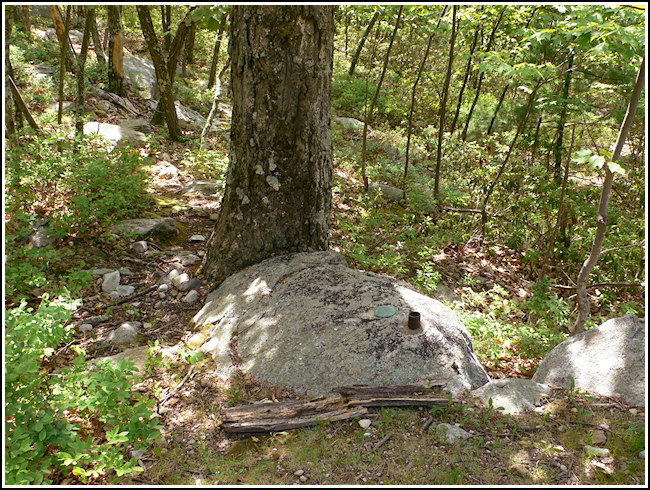
The old carriageway was very rocky and rutted, steep in spots. Although biking is often an efficient way to reach remote tri-stations, having the bikes along would have been more of a hindrance in this case. We hadn’t even considered it, really, because we know biking isn’t allowed anywhere at Sam’s Point. After a switchbacking climb of about 1.4 miles we reached the hairpin turn, the coordinates, and the station set into a boulder alongside the trail. Some sort of a pipe or segment of a pole is set into the boulder a few inches from the station disk; its purpose remains a mystery.
As usual, we quickly surveyed the woods for large boulders with disks set into them. In a matter of seconds we located RM 2, thanks in part to a pole—similar to the pole piece found near the station—that drew our attention. Our efforts and experience didn’t help much with RM 1, though. While we eventually zeroed in on a likely boulder, it was much too overgrown to clear with the limited tools we had with us. Without our metal detector we couldn’t even be sure we’d identified the correct boulder, but the box score measurements checked out and nothing else made much sense. I’m disappointed that we had to leave without recovering the entire set, but it happens. The “end of the world” message is no longer visible, although we found the outcropping on which it most likely had been painted. This time of year is thrilling in the woods, when the spring mud begins to dry up and bright green new life is everywhere. Regardless of how frustrating “green” becomes later in the year, when it means little more than a need to mow the lawn at least twice a week, now it is glorious and welcome!
Supper was also in Ellenville at Gaby’s Cafe, a new little Mexican restaurant that already has a strong reputation. Service was friendly and quick. Rich enjoyed his green enchiladas and I really liked my beef and chicken chimichangas with 3 sauces (red, white [cheese], and green, spooned over the chimis to look like the Mexican flag) and we both loved the black beans. Negra Modelo made the meal complete—or so we thought until we tried the homemade pineapple tequila. That really hit the spot!
