The days are getting short, the weather’s getting cold, and the rainy season is upon us. But just as we did throughout the Summer, Rich and I lucked out this Friday with a partly sunny, very colorful day. The temperature was in the 50s at its highest, but at least we stayed dry all day and were appropriately dressed for the Fall chill.
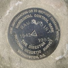
We hiked directly to Sam’s Point after parking and attempting to access the Conservation Center, which was locked up tight. The views along this eastern section of the Loop Road are stunning, if hiking the road itself is rather tedious. A quick check on the coordinates of the Sam’s Point tri-station upon reaching one of the expansive rock outcrops to the right of the trail told us (to our surprise) that we were within three hundred feet of the mark. Seeing no direct route to the station via the road, we bushwhacked up to the highest point (which we presumed, correctly, to be Sam’s Point) through pine and heavy scrub … emerging directly on top of the mark, at the platform with a side road leading directly to it. I suppose it’s no fun taking the easy route.
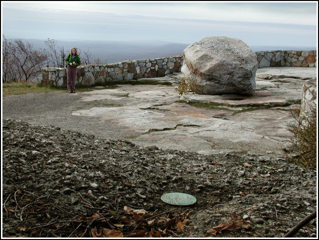
The station is in excellent condition, particularly given its exposed location. Both reference marks were found in fair condition at the given distance and direction from the station mark. As noted in the description, RM2 has suffered some damage from a sharp instrument. At the time we were unaware of the existence of an azimuth mark for this station, so we will have to wait until our next visit to search for and report on it. An updated to-reach will be written and submitted to NGS with our official recovery report.
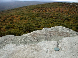
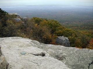
From the point can be seen the Shawangunk Ridge to the south, and the Wallkill Valley below. Magnificent even on a cloudy morning, the view must be literally breathtaking when the air is clear. And indeed, as we worked at the site the fog did begin to lift somewhat, giving us a view of the valley and the bright hues of the trees on the mountains opposite.
After finishing the recovery to our satisfaction, we continued north along the road, at the top of the hill turning right and then heading down toward the famous Ice Caves, and passing the aqua-blazed Long Path (which we would later follow to Verkeerderkill Falls) along the way. Just a few miles into our hike, and we were already getting hungry for wine, cheese, bread and strawberries—none of which we had with us. We were destined to starve, or overdose on candy.
 We soon descended into the Ice Caves, tectonic caves through which runs a trail that is part awesome rock scrambling, part wooden ladder and boardwalk wandering, and a small part tacky pseudo-adventuring (sorry, but those motion-sensor lights just ruined the ambiance for us!) Nevertheless, the experience was more challenging than I ever expected, and hilarious as well. I won’t forget the Grape Squeeze, the “Crab People … Crab People …” following us, and having to knock on “the door” and Rich having to save me from Gollum. I haven’t laughed so hard in years. After such a hot season the ice was long gone, but this was hardly a disappointment to us two Summerphiles.
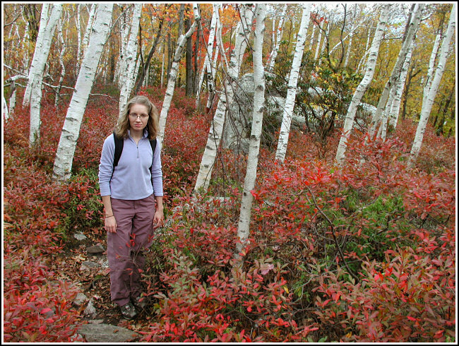
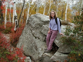
After escaping the Ice Caves with our bodies and minds mostly intact, we headed back up the hill to pick up the Long Path headed northeast toward the falls. For a sweet two-and a quarter miles we hiked a rocky, slightly downhill slope along the ridge with spectacular views of the entire valley—Storm King, our eternal beacon, of course—and the northern Shawangunk Ridge spread out before us nearly the entire time. The blueberry bushes have turned a brilliant red and cover so densely they look like a queen’s royal carpet, punctuated here and there by the jewel-like tones of pure emerald green pines and ferns and occasional golden oaks, and stark white birches. Against the sapphire blue sky, this made for a pleasing array of primary colors.
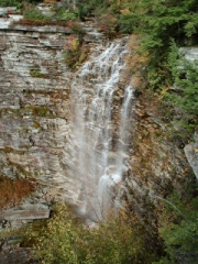
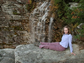
Our environment made an abrupt change as we got close to the falls. As thin streams of water, all contributors to the falls, began to appear at our feet, we were surrounded by hemlocks and laurel and the amazing vista was obscured. Soon, though, we worked our way over to the best viewing platform for the falls, where we certainly got a sense of the power of this veil of water falling over the nearly 200-foot cliffs. Even I was shaky standing right at the edge.
A brief rest and photo session helped us get our energy back, and we continued our journey, now moving northwest along the challenging High Point Trail. This is another beautiful, mostly level ridge trail (this time we could look south toward the ice caves), less rocky underfoot than Verkeerderkill Falls trail but with plenty of high rock scrambles along the way. I love hikes that require me to use my hands! High Point itself was another awesome 360° view and, like Butter Hill, the perfect place for a tri-station, the recovery of which we decided to leave for next time. We stopped briefly for a snack and to ponder just what features we might be seeing in the distance (among them several Catskills peaks, Skytop, and what we later determined to be Cape Pond and Rondout Reservoir). The sun was low in the sky by this point, and the breeze was picking up. We were both fighting internal battles between our hungry stomachs and our sleepy eyes! Eventually we decided that it was really too cold for a nap, and that we’d better get moving back toward the car if we wanted a reasonable chance of seeing our next meal before passing out from hunger.
A short but slightly confusing jaunt north and then west down a steep, gravelly slope brought us to the High Point Carriageway. It’s not exciting, but was a welcome cool down from the rest of the hike. We decided to bypass Indian Rock this time (hey, we have to leave something good for our next visit!) in order to get back to the car before darkness and chill set in. We passed the cell towers—one hundred feet from which I had no reception, note and photograph to T-Mobile to follow—and then Lake “Marzipan” before spotting the crumbling berry-pickers’ shacks off to the right. In fact, we puzzled over them for a few moments before I remembered having read about them in Rich’s hike book.
Sad to be leaving, we came slowly down the hill toward the Conservation Center, which again (still?) was closed. We signed out (9:15am-5:15pm—a day’s work!) and changed at the car. I was pretty much frozen from this point onward. After our beautiful Summer, I’d forgotten just how fast the air cools down when it’s dry and the sun sets early.
And now we were faced with the eternal and most vital question—where to obtain the meal we so craved??? What did Betty have in mind for us? Well, Betty had very few suggestions this time, so we decided to take a drive through Wurtsboro and if we saw nothing of interest, head to the Cornucopia Restaurant, where we dined after our trip to Bashakill in late August.
On our way down the mountain, we just happened to approach a pull-off just as the sun was beginning to set. What perfect timing! We watched the yellow ball descend behind the mountains and enjoyed the changing colors of the cliffs opposite us—from yellow to pink to purple. After the spell of the moment was broken, we headed on to Wurtsboro, quite a disappointing little town in terms of interesting dining prospects. So we made our decision—and off to the Cornucopia we went. I didn’t mind, because I’d been in the mood for sausages all day!
We started off with their unique salad bar—all tasty homemade favorites like potato salad, three-bean salad, carrot salad, pickled beets, cucumbers and seafood salad. For an appetizer we shared ravioli in a tomato and basil sauce. My entree was a deliciously filling pair of German bratwursts on top of sauerkraut, topped with crispy fried onions, and a potato pancake with applesauce on the side. Rich had the beef rouladen (we had to ask what that was, but he took a chance and it was tasty). I was a little too full for dessert (and no, I wasn’t feeling feverish, I was just full!). I fell quite soundly asleep on the way home.
