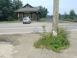
On a mid-July day too hot and much too humid to do anything but drive around in an air-conditioned car, Rich and I decided to check out the southern portion of the railbed near Clifton. (We had biked the northern part in May, exploring the Boar Hole and finding 39 JPN along the way.) I was hoping the southern half of the railbed would offer the same kind of scenic riding and easy approaches to the several benchmarks along its route. We couldn’t tell from the maps how accessible this portion would be nor how it would cross the Lehigh River, so we resolved to check out the area first by car and then come back with the bikes if possible.
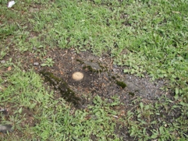
We easily found the point in Clifton at which the railbed intersected State Route 2013 from the northwest. While searching the other side of the road to find the point where the railbed picked up again, Rich noticed a witness post with a sign. Interesting! We figured there must have been a disk within a few yards, but were unable to find it at first. I finally uncovered it while digging around in the dirt with my shoe. When I saw the stamping I realized this must be BM1624 (15 C), a mark I’ve looked at several times on the map and datasheet. I was planning to save it for our ride along this portion of the railbed and didn’t even have the information with me today. Well, I’ll take ’em when and where I find ’em!
This end of the railbed didn’t look promising as it cuts through someone’s driveway and yard and beneath their house before disappearing into the woods again. We decided to drive on and explore a few other possible access points, none of which were viable until we reached Bradys Lake. We took a brief hike/trespass through a grassy path on a Christmas tree farm, where I found a small bush of huge, sweet, probably cultivated blueberries.
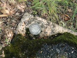
That unexpected benchmark find in Clifton was followed by another at Bradys Lake. Still determined to find an easy way to access the old railbed, we followed Route 2013 all the way to Route 215 and eventually to Route 940, and then followed Bradys Lake Road straight north toward the dam. Roundabout, but it’s really the only way to approach the lake. When we arrived in the parking lot, Rich indicated that there was another benchmark very close by—within forty feet, according to the coordinates he had pulled from the map. Those coordinates were quite good and after a few moments of searching I spotted the disk on the corner of a culvert passing beneath the road over the dam. A thick layer of asphalt has been cut back to reveal the mark. Nearby we noticed the baseline markers and pink-flagged stakes from recent survey work. I suspect that this mark may have been involved in the survey, although there was no solid evidence of this. The Bradys Lake sign is now missing, though its frame remains in place.
After all of our adventures thus far, we made our way to DLW 1889 in Tobyhanna, which I’d been interested in for some time because of the potential 1889 date of monumentation. We found the mark easily enough, though it was buried beneath a layer of fine gravel and dirt. But to my disappointment, 1889 was not the monumentation date but simply the elevation stamped on the disk. There is no record of the actual date this mark was set, but it’s possible it was set along with the nearby USGS disk DLW (LY1116) in 1932.
